|
20090905's Storm Report (1200 UTC - 1159 UTC)
|
< 090904 Reports
090906 Reports >
|
|
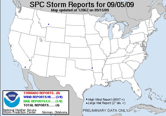
| Note: All data are considered preliminary |
| Tornado Reports (in CSV format) |
|---|
| No reports received |
| Hail Reports (in CSV format) |
|---|
Time | Size | Location | County | State | Lat | Lon | Comments |
| 2240 | 100 | 13 E MID HILLS RAWS | SAN BERNARDINO | CA | 3513 | 11518 | THE PARK SERVICE REPORTED QUARTER SIZE HAIL FELL ON THE MOJAVE NATIONAL PRESERVE NEAR CEDAR CANYON ROAD AND LANFAIR ROAD. (VEF) |
| Wind Reports (in CSV format) |
|---|
Time | Speed | Location | County | State | Lat | Lon | Comments |
| 1930 | UNK | 1 S WICKES | POLK | AR | 3429 | 9434 | LARGE TREE LIMBS WERE BLOWN DOWN ALONG HIGHWAY 71... JUST SOUTH OF WICKES. (LZK) |
| 0046 | UNK | 3 SE OCOTILLO WELLS | SAN DIEGO | CA | 3311 | 11610 | POWER POLE LEANING OVER AT 45 DEGREE ANGLE. (SGX) |
| 0056 | 58 | LIVINGSTON | PARK | MT | 4566 | 11056 | (BYZ) |
| Full report
in comma-separated values (CSV) format and in KML format.
| | Fields marked UNK are unknown |
| All Times UTC |
| Wind Gusts in MPH |
| Hail Sizes in 1/100 of an Inch (75 = 0.75") |
| LAT/LON in decimal degrees to two decimals, see SPC FAQ for more info |
| List of Weather Forecast Office 3-letter IDs appear in the report comments section |
|
|
|
Top/Storm Reports/Home
|
|


 @NWSSPC