|
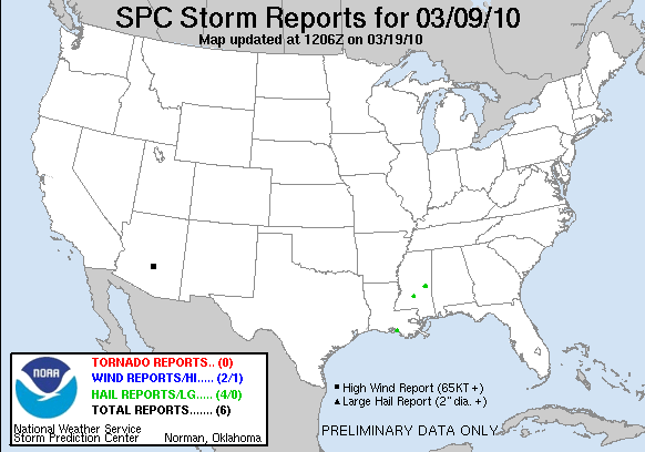
20100309's Storm Report (1200 UTC - 1159 UTC)
|
< 100308 Reports
100310 Reports >
|
|
| Note: All data are considered preliminary |
| Tornado Reports (in CSV format) |
|---|
| No reports received |
| Hail Reports (in CSV format) |
|---|
Time | Size | Location | County | State | Lat | Lon | Comments |
| 1420 | 100 | 3 NNE BURNS POINT | ST. MARY | LA | 2961 | 9151 | PUBLIC AT OIL REFINERY REPORTS QUARTER SIZE HAIL NEAR GORDY. (LCH) |
| 1920 | 100 | 6 SSW MENDENHALL | SIMPSON | MS | 3189 | 8992 | REPORTED ALONG BOGGAN RIDGE RD. TIME ESTIMATED. (JAN) |
| 2045 | 175 | COLLINSVILLE | LAUDERDALE | MS | 3249 | 8884 | (JAN) |
| 2045 | 125 | DUFFEE | NEWTON | MS | 3249 | 8893 | NICKEL TO HALF DOLLAR SIZE HAIL FELL FOR AROUND 5 MINUTES. (JAN) |
| Wind Reports (in CSV format) |
|---|
Time | Speed | Location | County | State | Lat | Lon | Comments |
| 1951 | 81 | APACHE JUNCTION | PINAL | AZ | 3340 | 11155 | 81 MPH WIND GUST AT IRONWOOD AND IDAHO RD (PSR) |
| 1957 | UNK | APACHE JUNCTION | PINAL | AZ | 3340 | 11155 | LARGE TREE BLOWN DOWN (PSR) |
| Full report
in comma-separated values (CSV) format and in KML format.
| | Fields marked UNK are unknown |
| All Times UTC |
| Wind Gusts in MPH |
| Hail Sizes in 1/100 of an Inch (175 = 1.75") |
| LAT/LON in decimal degrees to two decimals, see SPC FAQ for more info |
| List of Weather Forecast Office 3-letter IDs appear in the report comments section |
|
|
|
Top/Storm Reports/Home
|
|


 @NWSSPC