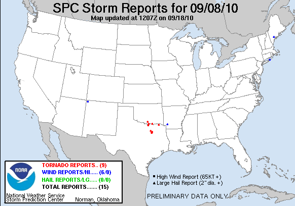
20100908's Storm Report (1200 UTC - 1159 UTC)
|
< 100907 Reports
100909 Reports >
|
|
| Note: All data are considered preliminary |
| Tornado Reports (CSV) (Raw Tornado CSV)(?) |
|---|
Time | | Location | County | State | Lat | Lon | Comments |
| 1905 | | COLBERT | BRYAN | OK | 3386 | 9650 | *** 1 INJ *** UPDATE FROM PREVIOUS T-STORM WIND DAMAGE ENTRY. A BRIEF TORNADO DAMAGED TO TWO HOMES AND OVERTURNED TWO TRUCKS. ONE OF THE TRUCK DRIVERS RECEIVED MINOR IN (OUN) |
| 2215 | | 3 S FERRIS | ELLIS | TX | 3249 | 9667 | SPOTTER REPORTED TORNADO 3 MILES SOUTH OF FERRIS. (FWD) |
| 2220 | | POST OAK | LAMAR | TX | 3372 | 9532 | POSSIBLE TORNADO NORTHEAST OF BLOSSOM NEAR POST OAK. 2 BARNS DAMAGED. 1 DESTROYED. HOMES WITH ROOF DAMAGE NEAR POST OAK. (FWD) |
| 2236 | | 5 SW SEAGOVILLE | DALLAS | TX | 3258 | 9659 | LIVE VIDEO OF TORNADO SOUTHWEST OF SEAGOVILLE. (FWD) |
| 2251 | | SEAGOVILLE | DALLAS | TX | 3263 | 9653 | LIVE VIDEO OF TORNADO NEAR SEAGOVILLE. (FWD) |
| 2316 | | 3 W HIGHLAND PARK | DALLAS | TX | 3282 | 9682 | TORNADO VISIBLE ON LIVE VIDEO 3 MILES WEST OF HIGHLAND PARK. (FWD) |
| 0000 | | 4 NW LONE GROVE | CARTER | OK | 3421 | 9731 | THE TORNADO WAS REPORTED BETWEEN PRAIRIE VALLEY AND ROLLING HILLS ROADS, DAMAGING TWO HOMES. THE TIME AND LOCATION ARE APPROXIMATE. (OUN) |
| 0028 | | 2 N LINDSAY | COOKE | TX | 3368 | 9723 | VISIBLE TORNADO REPOTED BY TRAINED SPOTTER JUST NORTH OF LINDSAY (FWD) |
| 0115 | | 6 S MARIETTA | LOVE | OK | 3385 | 9712 | BRIEF TOUCHDOWN WITH NO DAMAGE REPORTED. (OUN) |
| Hail Reports (CSV) (Raw Hail CSV)(?) |
|---|
| No reports received |
| Wind Reports (CSV) (Raw Wind CSV)(?) |
|---|
Time | Speed | Location | County | State | Lat | Lon | Comments |
| 1355 | UNK | EAST HAMPTON | SUFFOLK | NY | 4095 | 7228 | DOWNED TREES IN EAST HAMPTON VILLAGE (OKX) |
| 1711 | 65 | SEAGOVILLE | DALLAS | TX | 3263 | 9653 | 65 MPH WIND GUST REPORTED AT 175 AND HALL STREET IN SEAGOVILLE (FWD) |
| 1725 | UNK | SABATTUS | ANDROSCOGGIN | ME | 4412 | 7011 | TREE DOWN ON WILLIAMS ROAD AND ANOTHER DOWN ON SOUTHERLAND ROAD. TIME ESTIMATED (GYX) |
| 1905 | UNK | COLBERT | BRYAN | OK | 3386 | 9650 | EMERGENCY MANAGER RELAYED A PUBLIC REPORT OF DAMAGE TO A HOME. SUBSEQUENTLY MEDIA REPORTED A SEMI TRUCK BLOWN OVER ON HIGHWAY 69 AND DAMAGE TO STEEL POWER TRANSMISSION (OUN) |
| 2040 | UNK | 8 WNW HOPE | HEMPSTEAD | AR | 3371 | 9372 | TREE BLOWN DOWN AND ON FIRE ON HIGHWAY 73. (SHV) |
| 2200 | UNK | SHIPROCK | SAN JUAN | NM | 3679 | 10870 | MOBILE HOME OVERTURNED (ABQ) |
| Full report
in comma-separated values (CSV) format and in KML format.
|
| Raw full report
in comma-separated values (CSV) format |
| Click here to find out the differences between the regular and raw CSV files. |
| Fields marked UNK are unknown |
| All Times UTC |
| Wind Gusts in MPH |
| Hail Sizes in 1/100 of an Inch (175 = 1.75") |
| LAT/LON in decimal degrees to two decimals, see SPC FAQ for more info |
| List of Weather Forecast Office 3-letter IDs appear in the report comments section |
|
|
|
Top/Storm Reports/Home
|


 @NWSSPC