|
20140315's Storm Reports (1200 UTC - 1159 UTC) (Print Version)
|
< 140314 Reports
140316 Reports >
|
| Note: All Reports Are Considered Preliminary |
|
|
|
|

| Tornado Reports (CSV) (Raw Tornado CSV)(?) |
|---|
| No reports received |
| Hail Reports (CSV) (Raw Hail CSV)(?) |
|---|
Time | Size | Location | County | State | Lat | Lon | Comments |
| 2107 | 100 | 2 SW ABILENE | TAYLOR | TX | 3243 | 9976 | (SJT) |
| 2133 | 150 | GOLDSBORO | COLEMAN | TX | 3206 | 9968 | (SJT) |
| 2158 | 175 | 7 NE SILVER VALLEY | COLEMAN | TX | 3203 | 9946 | HAIL COVERING THE GROUND. MOST WERE PENNY SIZE ... BUT SOME WERE AS LARGE AS GOLF BALLS. (SJT) |
| 2202 | 100 | 5 E BAIRD | CALLAHAN | TX | 3240 | 9931 | HAIL COVERED INTERSTATE 20 ... WITH TRAFFIC SLOWING TO 20 MPH. NICKEL TO QUARTER SIZE HAIL. SOME CAR WINDSHIELD CRACKED OR BROKEN. (SJT) |
| 2230 | 175 | 4 NNE BURKETT | COLEMAN | TX | 3205 | 9920 | HAIL COVERING THE GROUND ON HIGHWAY 206. (SJT) |
| 2236 | 175 | CROSS CUT | BROWN | TX | 3203 | 9913 | GOLF BALL HAIL COVERING HIGHWAY 279. (SJT) |
| 2301 | 200 | 1 E MAY | BROWN | TX | 3198 | 9890 | (SJT) |
| 2320 | 175 | SIDNEY | COMANCHE | TX | 3195 | 9873 | (FWD) |
| 2337 | 100 | COMANCHE | COMANCHE | TX | 3190 | 9862 | QUARTER SIZE HAIL IN THE CITY OF COMMANCHE (FWD) |
| 0046 | 125 | HAMILTON | HAMILTON | TX | 3170 | 9812 | HALF DOLLAR SIZE HAIL 3 MILES NORTH OF HAMILTON ON COUNTY ROAD 101 (FWD) |
| 0607 | 100 | 3 NNE LUFKIN | ANGELINA | TX | 3137 | 9471 | QUARTER SIZE HAIL FALLING ON NORTH SIDE OF LUFKIN (SHV) |
| Wind Reports (CSV) (Raw Wind CSV)(?) |
|---|
Time | Speed | Location | County | State | Lat | Lon | Comments |
| 2120 | 60 | 3 NE POTOSI | TAYLOR | TX | 3237 | 9965 | SPOTTER ALSO REPORTED A WALL CLOUD 2 MILES TO THE SOUTH. (SJT) |
| 0011 | UNK | PLANO | COLLIN | TX | 3302 | 9672 | FENCES BLOWN DOWN AND SOME SHINGLES BLOWN OFF A ROOF IN PLANO AT THE INTERSECTION OF CUSTER RD. AND HEDGECOXE RD. (FWD) |
| 0025 | UNK | LUCAS | COLLIN | TX | 3308 | 9658 | POWERLINES DOWN AT HORSEMAN AND ORR IN LUCAS. (FWD) |
| 0140 | 60 | HASKELL | HASKELL | TX | 3316 | 9973 | NICKEL SIZE HAIL ACCOMPANIED THE STORM AS WELL. (SJT) |
| 0144 | UNK | PARIS | LAMAR | TX | 3365 | 9553 | ROOF COLLAPSED TRAPPING 1 PERSON INSIDE AT 900 SW 3RD STREET. PERSON WAS NOT HURT. (FWD) |
| 0330 | 60 | MIDLAND INTERNATIONAL A | MIDLAND | TX | 3194 | 10219 | MIDLAND INTERNATIONAL ASOS REPORTED 60 MPH WIND GUST FROM NEARBY THUNDERSTORM (MAF) |
|
| Filtered Tornado Reports (CSV) (Raw Tornado CSV)(?) |
|---|
| No reports received |
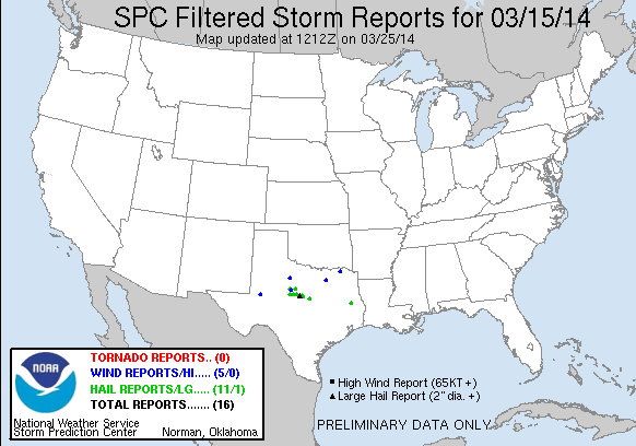
| Filtered Hail Reports (CSV) (Raw Hail CSV)(?) |
|---|
Time | Size | Location | County | State | Lat | Lon | Comments |
| 2107 | 100 | 2 SW ABILENE | TAYLOR | TX | 3243 | 9976 | (SJT) |
| 2133 | 150 | GOLDSBORO | COLEMAN | TX | 3206 | 9968 | (SJT) |
| 2158 | 175 | 7 NE SILVER VALLEY | COLEMAN | TX | 3203 | 9946 | HAIL COVERING THE GROUND. MOST WERE PENNY SIZE ... BUT SOME WERE AS LARGE AS GOLF BALLS. (SJT) |
| 2202 | 100 | 5 E BAIRD | CALLAHAN | TX | 3240 | 9931 | HAIL COVERED INTERSTATE 20 ... WITH TRAFFIC SLOWING TO 20 MPH. NICKEL TO QUARTER SIZE HAIL. SOME CAR WINDSHIELD CRACKED OR BROKEN. (SJT) |
| 2230 | 175 | 4 NNE BURKETT | COLEMAN | TX | 3205 | 9920 | HAIL COVERING THE GROUND ON HIGHWAY 206. (SJT) |
| 2236 | 175 | CROSS CUT | BROWN | TX | 3203 | 9913 | GOLF BALL HAIL COVERING HIGHWAY 279. (SJT) |
| 2301 | 200 | 1 E MAY | BROWN | TX | 3198 | 9890 | (SJT) |
| 2320 | 175 | SIDNEY | COMANCHE | TX | 3195 | 9873 | (FWD) |
| 2337 | 100 | COMANCHE | COMANCHE | TX | 3190 | 9862 | QUARTER SIZE HAIL IN THE CITY OF COMMANCHE (FWD) |
| 0046 | 125 | HAMILTON | HAMILTON | TX | 3170 | 9812 | HALF DOLLAR SIZE HAIL 3 MILES NORTH OF HAMILTON ON COUNTY ROAD 101 (FWD) |
| 0607 | 100 | 3 NNE LUFKIN | ANGELINA | TX | 3137 | 9471 | QUARTER SIZE HAIL FALLING ON NORTH SIDE OF LUFKIN (SHV) |
| Filtered Wind Reports (CSV) (Raw Wind CSV)(?) |
|---|
Time | Speed | Location | County | State | Lat | Lon | Comments |
| 2120 | 60 | 3 NE POTOSI | TAYLOR | TX | 3237 | 9965 | SPOTTER ALSO REPORTED A WALL CLOUD 2 MILES TO THE SOUTH. (SJT) |
| 0011 | UNK | PLANO | COLLIN | TX | 3302 | 9672 | FENCES BLOWN DOWN AND SOME SHINGLES BLOWN OFF A ROOF IN PLANO AT THE INTERSECTION OF CUSTER RD. AND HEDGECOXE RD. (FWD) |
| 0140 | 60 | HASKELL | HASKELL | TX | 3316 | 9973 | NICKEL SIZE HAIL ACCOMPANIED THE STORM AS WELL. (SJT) |
| 0144 | UNK | PARIS | LAMAR | TX | 3365 | 9553 | ROOF COLLAPSED TRAPPING 1 PERSON INSIDE AT 900 SW 3RD STREET. PERSON WAS NOT HURT. (FWD) |
| 0330 | 60 | MIDLAND INTERNATIONAL A | MIDLAND | TX | 3194 | 10219 | MIDLAND INTERNATIONAL ASOS REPORTED 60 MPH WIND GUST FROM NEARBY THUNDERSTORM (MAF) |
| Full report in comma-separated values (CSV) format and in KML format. |
| Full filtered report in comma-separated values (CSV) format and in KML format. |
| KML files are created with time-enabled placemarks compatible with Google Earth Time Slider. |
| Raw full report in comma-separated values (CSV) format |
| Fields marked UNK are unknown |
| All Times UTC |
| Wind Gusts in MPH |
| Hail Sizes in 1/100 of an Inch (175 = 1.75") |
| LAT/LON in decimal degrees to two decimals, see SPC FAQ for more info |
| List of Weather Forecast Office 3-letter IDs appear in the report comments section |
|
|
|
Top/Storm Reports/Home
|
|
|


 @NWSSPC