|
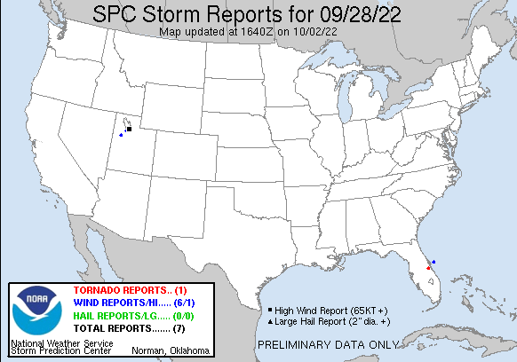
20220928's Storm Reports (20220928 1200 UTC - 20220929 1159 UTC) (Print Version)
|
< 220927 Reports
220929 Reports >
|
| Note: All Reports Are Considered Preliminary |
|
|
|
|
| Tornado Reports (CSV) (Raw Tornado CSV)(?) |
|---|
Time | | Location | County | State | Lat | Lon | Comments |
| 1929 | | 5 W CAMP HOLLY FISH CAM | BREVARD | FL | 2809 | 8083 | MULTIPLE SOCIAL MEDIA VIDEOS SHOWED A BRIEF TORNADO SUPPORTED BY RADAR IMAGERY CROSSING HWY 192 JUST EAST OF THE BREVARD/OSCEOLA COUNTY LINE BETWEEN SAPLING LANE AND BU (MLB) |
| Hail Reports (CSV) (Raw Hail CSV)(?) |
|---|
| No reports received |
| Wind Reports (CSV) (Raw Wind CSV)(?) |
|---|
Time | Speed | Location | County | State | Lat | Lon | Comments |
| 1300 | 58 | 25 ENE PORT CANAVERAL | AMZ572 | FL | 2851 | 8019 | (MLB) |
| 1750 | 69 | 2 SSW GRANTSVILLE | TOOELE | UT | 4056 | 11248 | GRANTSVILLE SOUTH SENSOR. (SLC) |
| 2355 | 59 | 16 SW DUGWAY | TOOELE | UT | 4010 | 11298 | TOWER GRID SENSOR DPG11 (SLC) |
| 0150 | 60 | 5 NE LAKE PT | SALT LAKE | UT | 4073 | 11221 | (SLC) |
| 0150 | 75 | 10 WNW WEST VALLEY CITY | SALT LAKE | UT | 4074 | 11220 | (SLC) |
| 0200 | 70 | 4 NNE LAKE PT | TOOELE | UT | 4072 | 11223 | (SLC) |
|

| Filtered Tornado Reports (CSV) (Raw Tornado CSV)(?) |
|---|
Time | | Location | County | State | Lat | Lon | Comments |
| 1929 | | 5 W CAMP HOLLY FISH CAM | BREVARD | FL | 2809 | 8083 | MULTIPLE SOCIAL MEDIA VIDEOS SHOWED A BRIEF TORNADO SUPPORTED BY RADAR IMAGERY CROSSING HWY 192 JUST EAST OF THE BREVARD/OSCEOLA COUNTY LINE BETWEEN SAPLING LANE AND BU (MLB) |
| Filtered Hail Reports (CSV) (Raw Hail CSV)(?) |
|---|
| No reports received |
| Filtered Wind Reports (CSV) (Raw Wind CSV)(?) |
|---|
Time | Speed | Location | County | State | Lat | Lon | Comments |
| 1300 | 58 | 25 ENE PORT CANAVERAL | AMZ572 | FL | 2851 | 8019 | (MLB) |
| 1750 | 69 | 2 SSW GRANTSVILLE | TOOELE | UT | 4056 | 11248 | GRANTSVILLE SOUTH SENSOR. (SLC) |
| 2355 | 59 | 16 SW DUGWAY | TOOELE | UT | 4010 | 11298 | TOWER GRID SENSOR DPG11 (SLC) |
| 0150 | 75 | 10 WNW WEST VALLEY CITY | SALT LAKE | UT | 4074 | 11220 | (SLC) |
| 0200 | 70 | 4 NNE LAKE PT | TOOELE | UT | 4072 | 11223 | (SLC) |
| The Storm Reports page is organized based on reports received from 1200 UTC to 1159 UTC the next day. For example, storm report page for 20150430 covers reports from 20150430 at 1200 UTC to 20150501 at 1159 UTC. |
| Full report in comma-separated values (CSV) format and in KML format. |
| Full filtered report in comma-separated values (CSV) format and in KML format. |
| KML files are created with time-enabled placemarks compatible with Google Earth Time Slider. |
| Raw full report in comma-separated values (CSV) format. |
| Fields marked UNK are unknown. |
| All Times UTC. |
| Wind Gusts in MPH. |
| Hail Sizes in 1/100 of an Inch (175 = 1.75") |
| LAT/LON in decimal degrees to two decimals, see SPC FAQ for more info. |
| List of Weather Forecast Office 3-letter IDs appear in the report comments section. |
|
|
|
Top/Storm Reports/Home
|
|
|


 @NWSSPC