Storm Prediction Center Day 1 Fire Weather Outlook
Created: Thu Dec 7 16:11:03 UTC 2017 (
![]() |
| ![]() )
)
|
Click for Day 1 FireWX Areal Outline Product
ZCZC SPCFWDDY1 ALL
FNUS21 KWNS 071610
Day 1 Fire Weather Outlook
NWS Storm Prediction Center Norman OK
1010 AM CST Thu Dec 07 2017
Valid 071700Z - 081200Z
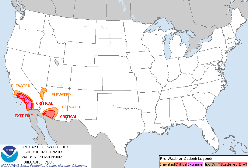
...EXTREMELY CRITICAL FIRE WEATHER AREA FOR PORTIONS OF SOUTHERN
CALIFORNIA...
...CRITICAL FIRE WEATHER AREA FOR PORTIONS OF SOUTHERN CALIFORNIA...
...CRITICAL FIRE WEATHER AREA FOR PORTIONS OF SOUTHERN ARIZONA...
The ongoing forecast is on track with dangerous and extremely
critical fire weather conditions remaining likely especially in
portions of southern California. Gusty easterly/northeasterly winds
will increase to 30+ mph (with gusts potentially exceeding 60 mph in
terrain-favored areas and higher elevations). Very dry surface
conditions will also develop by afternoon, with RH values of 3-15%
and very dry fuels supporting rapid spread of fires today. RH
values will remain very low overnight (8-15%), with dangerous fire
weather conditions continuing through early Friday.
Another area of critical fire weather conditions will exist across
portions of southern Arizona, where 20-25 mph northeasterly surface
flow will combine with 7-15% RH values during peak heating hours.
Another area of elevated fire weather conditions will develop in
portions of the Lower Colorado River Valley, where northerly flow
will approach 20 mph during the afternoon amidst very low (9-15%)
RH.
For additional information, see the previous forecast below.
..Cook.. 12/07/2017
.PREV DISCUSSION... /ISSUED 0142 AM CST Thu Dec 07 2017/
...Synopsis...
Dangerous and extremely critical fire weather conditions are
expected across a broad portion of southern CA today.
Within large-scale upper troughing over much of the central/eastern
CONUS, an embedded positively tilted upper trough will continue
moving south-southeastward over the Rockies/Plains early this
morning. Enhanced north/northeasterly low- and mid-level flow around
30-40 kt on the western periphery of this upper trough has
overspread the Southwest and southern CA, and these enhanced winds
aloft will continue through at least the afternoon hours. Highly
amplified upper ridging will remain over the eastern Pacific and
parts of the West Coast.
At the surface, a broad area of high pressure over the northern
Rockies and Great Basin is in the process of restrengthening early
this morning. A corresponding increase in offshore winds will occur
across much of southern CA through this evening, supporting high-end
critical to extremely critical fire weather conditions.
...Portions of Southern CA...
The LAX-TPH pressure difference has strengthened to around -14 mb
over the past several hours. Latest surface observations across
southern CA show multiple locations in the mountains/foothills of
Ventura and Los Angeles counties with sustained northerly to
northeasterly winds of 30-35 mph, and gusts to 50-60 mph. RH values
remain critically lowered in the 7-15% range for many areas.
Given the strengthening surface pressure gradient plus the enhanced
low- and mid-level flow mentioned above, sustained northeasterly to
easterly winds of 30-40 mph will occur across much of the higher
terrain of southern CA this morning through at least the evening
hours. This includes the mountains/foothills and adjacent areas of
far southeastern Santa Barbara, Ventura, Los Angeles, Orange,
southwestern San Bernardino, western Riverside, and central/eastern
San Diego counties. Stronger gusts of 50-80 mph will likely occur in
favored higher terrain and passes where flow channeling will be
maximized. RH values will easily fall/remain in the 5-10% range this
afternoon/evening due to diurnal heating and low-level downslope
warming/drying effects. Coupled with very dry/receptive fuels, these
expected meteorological conditions support the continuation of an
extremely critical fire weather area with mainly small changes.
Large fire spread and extreme fire behavior will occur with any
new/ongoing fires.
Surrounding the extremely critical designation, critical fire
weather conditions are anticipated across a broader portion of
southern CA. Here, sustained winds of 20-30 mph, with gusts to 40-50
mph, and RH values of 5-15% will be common. Both downtown Los
Angeles and the LA basin along with San Diego have been included in
a critical delineation. These dangerous fire weather conditions are
forecast to continue through the entire Day 1/Thursday period,
although the surface pressure gradient will likely relax slightly
late tonight into Friday morning. This should act to lessen winds
somewhat across southern CA late in the period.
...Portions of Southern AZ...
A critical area has been included for portions of southern AZ where
sustained winds of 20-30 mph will overlap with RH values lowered
into the 5-15% range for a few hours this afternoon. Latest fuel
guidance indicates fine fuels are now receptive to new fire starts.
These critical fire weather conditions are expected to quickly
diminish late this evening with the loss of diurnal heating and
corresponding RH recovery.
...Please see www.spc.noaa.gov/fire for graphic product...