Storm Prediction Center Day 1 Fire Weather Outlook
Created: Fri Nov 9 15:39:03 UTC 2018 (
![]() |
| ![]() )
)
|
Click for Day 1 FireWX Areal Outline Product
ZCZC SPCFWDDY1 ALL
FNUS21 KWNS 091538
Day 1 Fire Weather Outlook
NWS Storm Prediction Center Norman OK
0938 AM CST Fri Nov 09 2018
Valid 091700Z - 101200Z
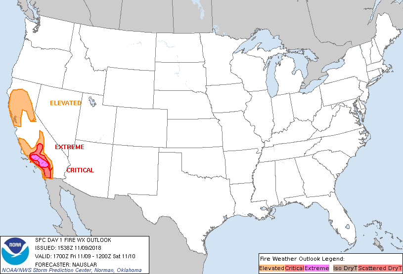
...EXTREMELY CRITICAL FIRE WEATHER AREA FOR PORTIONS OF THE SOUTH
COASTAL RANGES INTO THE FOOTHILLS OF SOUTHERN CALIFORNIA...
...CRITICAL FIRE WEATHER AREA FOR PORTIONS OF SOUTHERN CALIFORNIA...
Ongoing wildfires should remain resistant to control/suppression,
especially across portions of southern California, through today
given the critical/extremely critical fire weather conditions.
Otherwise, forecast remains on track and no changes are necessary.
Please see the discussion below for more details.
..Nauslar.. 11/09/2018
.PREV DISCUSSION... /ISSUED 1251 AM CST Fri Nov 09 2018/
...Synopsis...
Modest upper-level flow, prevalent along the upstream portion of a
longwave trough, will traverse California throughout the day. An
inverted surface trough will remain just offshore of California,
with a 1030+ mb high situated over the Great Basin. The net result
will be the development of a very strong synoptic scale pressure
gradient, conducive for a strong offshore flow event, especially in
terrain-favoring areas that may channel surface flow and support
stronger wind speeds.
...Portions of Southern California...
Widespread critical wind/RH conditions will be ongoing at the start
of the day (i.e. 1200-1500 UTC), along the Santa Ynez to Laguna
Mountain ranges in association with strong offshore flow. Latest
high-resolution model guidance continues to indicate channeled
downslope flow in terrain-favored areas along the western/southern
slopes of the Santa Ynez, San Gabriel, and Santa Ana Mountains
during the morning hours, with north-northeasterly winds sustaining
near 30 mph, hence the continuation of the extremely critical risk
delineation for these areas. In addition, critically low RH and
downslope flow contributing to 15 mph winds are also expected during
the morning hours along southern portions of the Sierra and the
south Coast Ranges, with an elevated delineation in effect for these
areas. During the late morning/early afternoon hours, channeled flow
in terrain induced areas will weaken with time, with elevated to
locally critical wind/RH conditions persisting across portions of
southwest California through the remainder of the afternoon.
Thereafter, as the synoptic scale pressure gradient begins to relax
with the eastward departure of the longwave trough and associated
surface high pressure, surface winds should drop to marginally
elevated thresholds by the end of period.
...Northern California...
Elevated to locally critical winds (15-20 mph) will be ongoing
during the early morning hours, particularly along the western
slopes of the Sierra and northern Coast Ranges. While critically low
RH will remain across most of the discussion area throughout the
morning/afternoon hours, surface winds are expected to weaken below
15 mph by noon, as the synoptic-scale pressure gradient is expected
to diminish across northern California first, before weakening
farther south.
...Please see www.spc.noaa.gov/fire for graphic product...