Storm Prediction Center Day 1 Fire Weather Outlook
Created: Thu Nov 19 07:58:02 UTC 2020 (
![]() |
| ![]() )
)
| |||||||||
Click for Day 1 FireWX Areal Outline Product
ZCZC SPCFWDDY1 ALL
FNUS21 KWNS 190757
Day 1 Fire Weather Outlook
NWS Storm Prediction Center Norman OK
0157 AM CST Thu Nov 19 2020
Valid 191200Z - 201200Z
...Synopsis...
Zonal upper flow will prevail across the CONUS, with surface high
pressure dominating the eastern and northwestern U.S through the
period. Broad surface lee troughing across the southern
Plains/Missouri Valley and downslope flow along the lee of the
Rockies will promote dry and breezy conditions across portions of
the High Plains and central CONUS, where modest wildfire-spread
potential will exist.
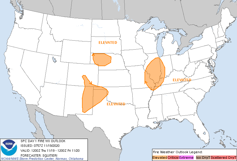
...Southern High Plains...
Latest guidance consensus depicts 15-25 mph sustained westerly winds
during the afternoon. Some model guidance suggests that RH will
struggle to drop below 20%. However, previous days of downslope flow
have shown RH dropping into the Elevated range, and this trend is
expected to continue this afternoon. With fuels being at least
modestly receptive to fire spread, an Elevated delineation has been
continued.
...Portions of western into central Nebraska...
Similar to the southern High Plains, downslope flow, along with
downward momentum transport of the stronger flow aloft, is expected
to foster 15-25 mph sustained westerly surface winds atop fuels that
are at least marginally receptive to fire spread. Guidance consensus
suggests that RH will dip mainly into the 20-25% range by afternoon
peak heating. The relatively favorable winds and RH are expected to
overlap long enough to warrant the continuation of an Elevated area.
...Portions of the Midwest...
Dry air from portions of the Southeast is expected to move northwest
into parts of the Midwest (mainly Missouri, Illinois and Indiana) by
afternoon as 20+ mph sustained southwesterly winds (with higher
gusts) overlaps 25-35% RH. Though much of the area has experienced
appreciable rainfall within the past week, rapid drying of the finer
fuels, along with the extent of the surface wind field, may
compensate to promote some threat for wildfire spread, necessitating
the Elevated highlights in place.
..Squitieri.. 11/19/2020
...Please see www.spc.noaa.gov/fire for graphic product...