Storm Prediction Center Day 2 Fire Weather Outlook
Created: Wed Nov 24 07:50:02 UTC 2021 (
![]() |
| ![]() )
)
|
Click for Day 2 FireWX Areal Outline Product (KWNSPFWFD2)
ZCZC SPCFWDDY2 ALL
FNUS22 KWNS 240749
Day 2 Fire Weather Outlook
NWS Storm Prediction Center Norman OK
0149 AM CST Wed Nov 24 2021
Valid 251200Z - 261200Z
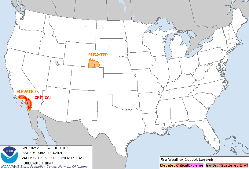
...CRITICAL FIRE WEATHER AREA FOR PORTIONS OF SOUTHERN CALIFORNIA...
...Synopsis...
On Thursday, a closed midlevel low is forecast to develop off of
Baja California, as the northern portion of the upper-level trough
pushes eastward across the Great Lakes Region. At the surface, high
pressure over the Great Basin will slowly weaken throughout the day.
...Portions of Southern California...
Critical fire weather conditions are expected to be ongoing at the
beginning of the period on Thursday, as the offshore pressure
gradient peaks. Despite a gradual weakening of the pressure
gradient throughout the rest of the day, critical fire weather
conditions will persist and expand southward in conjunction with the
movement of the upper-level support (i.e., enhanced northeasterly
flow aloft). Although the peak wind gusts may weaken throughout the
day, gusts of 40-50 mph will still be possible in favored locations
in conjunction with widespread single-digit RH values in the
afternoon.
...Southeastern Wyoming and the Southwestern Nebraska Panhandle...
Although high temperatures are forecast to remain relatively cool
(40s to low 50s F), a very dry airmass and enhanced
westerly-to-northwesterly flow aloft will likely lead to elevated
fire weather conditions. Boundary-layer heating and mixing are
likely to yield afternoon RH values around 15% and sustained winds
approaching 20 mph. Dry fuels (ERC and 100-hour fuel moisture values
near the 90th percentile) and lack of recent rainfall support
elevated fire weather concerns.
..Jirak.. 11/24/2021
...Please see www.spc.noaa.gov/fire for graphic product...