|
| Mesoscale Discussion 735 |
|
< Previous MD
Next MD >
|
|
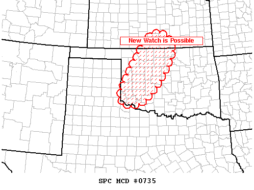
   MESOSCALE DISCUSSION 0735
   NWS STORM PREDICTION CENTER NORMAN OK
   0926 PM CDT SUN MAY 06 2007

   AREAS AFFECTED...WRN/NRN OK...SCNTRL KS

   CONCERNING...TORNADO WATCH 246...

   VALID 070226Z - 070330Z

   THE SEVERE WEATHER THREAT FOR TORNADO WATCH 246 CONTINUES.

   ORGANIZED THUNDERSTORMS CONTINUE ACROSS WRN OK AND SOUTH CENTRAL
   KS...WELL WEST OF DEVELOPING LLJ.  THIS ACTIVITY WILL LIKELY
   CONTINUE DUE TO THE PRESENCE OF MODEST INSTABILITY AND DEEP LAYER
   SHEAR.  HOWEVER...THERE IS SOME CONCERN THAT GREATEST SEVERE THREAT
   MAY ACTUALLY BE HAIL OR LOCALLY STRONG WINDS.  WILL CONTINUE TO
   MONITOR FOR POSSIBLE WATCH EXTENSION...OR REPLACEMENT.

   ..DARROW.. 05/07/2007


   ATTN...WFO...ICT...OUN...DDC...AMA...

   34750002 37679823 36899701 34649862
|
|
Top/All Mesoscale Discussions/Forecast Products/Home
|
|


 @NWSSPC