|
| Mesoscale Discussion 257 |
|
< Previous MD Next MD >
|
|
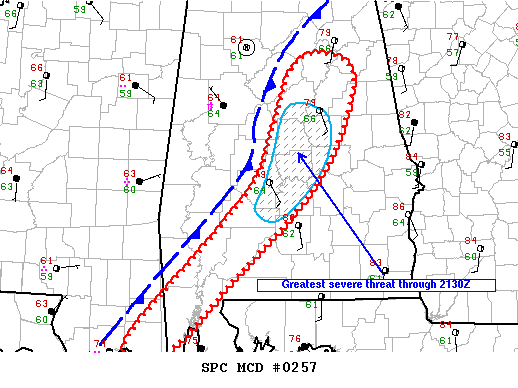
   Mesoscale Discussion 0257
   NWS Storm Prediction Center Norman OK
   0256 PM CDT Sat Apr 14 2018

   Areas affected...extreme southeast Mississippi and southwest through
   north central Alabama into the far western FL panhandle

   Concerning...Tornado Watch 48...

   Valid 141956Z - 142130Z

   The severe weather threat for Tornado Watch 48 continues.

   SUMMARY...Threat for damaging wind and a couple of tornadoes
   persists across the remaining part of tornado watch 48. The greatest
   short-term damaging wind threat appears to be with portion of the
   line moving through central AL. Storms will approach the
   eastern-most counties in the WW soon and another row of counties can
   be added if needed.

   DISCUSSION...Greatest short-term severe threat for damaging wind
   appears to be with portion of line moving through central AL. This
   segment of the line continues east at 25-30 kt and will approach the
   border of the WW soon where some severe threat might persist for
   another row of counties farther east. However, surface data show a
   substantial reduction in dewpoints over east central through
   northeast AL, suggesting a more marginal thermodynamic environment
   that could promote a weakening trend.

   Farther southwest across southwestern AL and southeast MS, the line
   is advancing much slower. Some models suggest development of a weak
   meso-low over the northwest gulf that will track northeast into
   southwest AL along this portion of the boundary this evening. If
   this scenario plays out, the far southeast portion of the WW would
   remain free of storms until this evening when the line once again
   begins to accelerate as the meso-low and associated upper impulse
   shift northeast.

   ..Dial.. 04/14/2018

   ...Please see www.spc.noaa.gov for graphic product...

   ATTN...WFO...BMX...MOB...LIX...

   LAT...LON   31628782 32368715 33018690 33658665 33818620 33498583
               32348634 31238747 30558813 30238865 30548883 31628782
|
|
Top/All Mesoscale Discussions/Forecast Products/Home
|
|


 @NWSSPC