|
| Mesoscale Discussion 303 |
|
< Previous MD Next MD >
|
|
Mesoscale Discussion 0303
NWS Storm Prediction Center Norman OK
1024 AM CDT Tue May 01 2018
Areas affected...Far northwest MO into south-central IA
Concerning...Severe potential...Watch unlikely
Valid 011524Z - 011800Z
Probability of Watch Issuance...5 percent
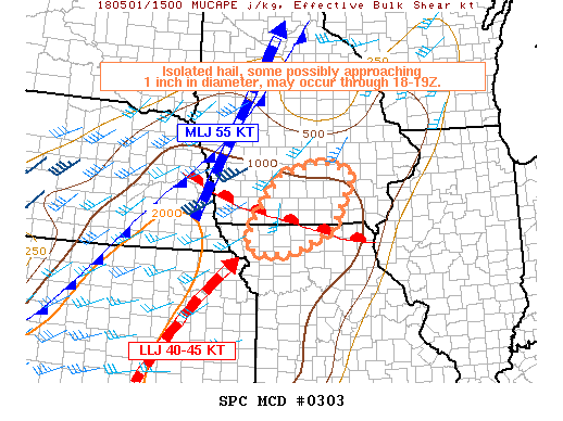
SUMMARY...Isolated hail approaching 1 inch in diameter will be
possible into the early afternoon from far northwest Missouri into
south-central Iowa. Low expected coverage of a severe hail threat
precludes the need for a watch.
DISCUSSION...Mid-late morning trends in mosaic radar imagery
indicated some increase in thunderstorm development within the
west/southwest extent of a cluster of convection/embedded storms
spreading to the east-northeast across northern MO into central IA.
12Z observed sounding analysis indicated this activity is elevated
near and north of a warm front draped to the southeast across
northern MO. A weakening, though still modest, southwesterly
low-level jet up to 45 kt is supporting low-level warm advection
into the western extent of aforementioned MO/IA cluster of storms.
Ascent within the nose of this jet combined with the entrance region
of a 55-kt 500-mb jet extending from eastern NE into the upper
Mississippi Valley will prove favorable in supporting additional
storms into the early afternoon, before these features weaken/depart
this region.
MRMS MESH data indicated a few storms with possible hail approaching
1 inch between 1430-15Z. Although trends have diminished since 15Z,
colder 500-mb temperatures at the TOP 12Z sounding spreading
northeast into the early afternoon combined with effective bulk
shear for storm organization suggest hail could approach 1 inch
through 18-19Z.
..Peters/Grams.. 05/01/2018
...Please see www.spc.noaa.gov for graphic product...
ATTN...WFO...DVN...DMX...EAX...
LAT...LON 41609402 41909288 41659208 40509263 40019370 39979440
40099489 40639477 41609402
|
|
Top/All Mesoscale Discussions/Forecast Products/Home
|
|


 @NWSSPC