|
| Mesoscale Discussion 319 |
|
< Previous MD Next MD >
|
|
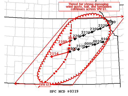
   Mesoscale Discussion 0319
   NWS Storm Prediction Center Norman OK
   0518 PM CDT Wed May 02 2018

   Areas affected...Central/Eastern KS

   Concerning...Tornado Watch 61...

   Valid 022218Z - 022345Z

   The severe weather threat for Tornado Watch 61 continues.

   SUMMARY...Threat for all severe hazards, including wind gusts in
   excess of 60 kt and tornadoes, continues across central and eastern
   KS.

   DISCUSSION...Well-developed line of thunderstorms continues to move
   across central KS. Northern end of this line has recently shown an
   increase in forward speed as well as a sharpening of the
   reflectively gradient along the leading edge. These trends coupled
   with recent velocity data from KTWX suggest this portion of the line
   has matured into an organized MCS capable of strong damaging wind
   gusts, a few of which could be greater that 60 kt. Tornadoes are
   also possible, particularly along the surging portion of the line
   where mesovorticies within the line are most likely. Storm motion
   for this portion of the MCS is currently estimated as 245 degrees at
   45 kt.

   Farther south, KICT radar imagery shows the outflow has surged ahead
   of the line from McPherson county KS southwestward to Barber county.
   As a result, the damaging wind threat is a bit less here than areas
   farther north. However, the downstream airmass is moderately
   unstable and surface winds are favorably oriented (i.e. from the
   southeast), so there is some potential for re-organization of this
   portion of the line.

   ..Mosier.. 05/02/2018

   ...Please see www.spc.noaa.gov for graphic product...

   ATTN...WFO...EAX...OAX...TOP...ICT...GID...DDC...

   LAT...LON   39449783 39989711 40169637 40159584 39989547 39819524
               39629511 39439508 39089523 38759548 38299598 37489703
               37069844 37499924 39449783
|
|
Top/All Mesoscale Discussions/Forecast Products/Home
|
|


 @NWSSPC