|
| Mesoscale Discussion 14 |
|
< Previous MD Next MD >
|
|
Mesoscale Discussion 0014
NWS Storm Prediction Center Norman OK
1037 AM CST Fri Jan 11 2019
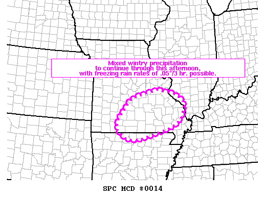
Areas affected...south-central and southeast Missouri and into
adjacent far northern Arkansas
Concerning...Winter mixed precipitation
Valid 111637Z - 112230Z
SUMMARY...Mixed wintry precipitation -- including potential for
three-hour freezing rain accumulation of greater than .05" locally
-- will continue across the Ozarks area and vicinity.
DISCUSSION...Latest radar loop continues to show an expansive area
of precipitation streaming northeastward across Texas and Oklahoma
and into Kansas/Missouri/Arkansas. The precipitation is occurring
within a zone of strong warm advection ahead of an upper trough
moving slowly eastward out of the Rockies, and an associated surface
low analyzed over the Texas Panhandle this morning.
Temperatures are above freezing across much of the area where
precipitation is falling -- and should remain above freezing in
these areas through this afternoon. The main exception is across
the Ozarks region of Missouri and eastward across the
mid-Mississippi Valley. Here, surface temperatures range from
roughly 29 to 32 degrees -- with some potential for evaporative
cooling in the lower troposphere (with surface dewpoints still in
the low to mid 20s at some sites).
Light rain -- and local areas of freezing rain -- have been observed
across portions of the discussion area this morning, along with
light snow in a few areas. While the aforementioned evaporative
cooling at low levels may allow a transition to somewhat more
widespread areas of light snow at times, the offsetting effect of
low-level warm advection suggests that light freezing rain will
remain at least a part of the mix through the afternoon, as repeated
rounds of precipitation spread northeastward across the area.
Accumulations of ice may exceed rates .05" in three hours locally,
particularly over higher terrain areas of south central and
southeast Missouri.
..Goss.. 01/11/2019
...Please see www.spc.noaa.gov for graphic product...
ATTN...WFO...PAH...LSX...LZK...SGF...
LAT...LON 38399099 38199001 37788948 37098971 36749026 36229195
36219268 36689324 37179311 38029240 38399099
|
|
Top/All Mesoscale Discussions/Forecast Products/Home
|
|


 @NWSSPC