|
| Mesoscale Discussion 129 |
|
< Previous MD Next MD >
|

|
   Mesoscale Discussion 0129
   NWS Storm Prediction Center Norman OK
   0526 PM CST Sat Feb 23 2019

   Areas affected...Far eastern NE...western/central IA...southern MN

   Concerning...Heavy snow

   Valid 232326Z - 240430Z

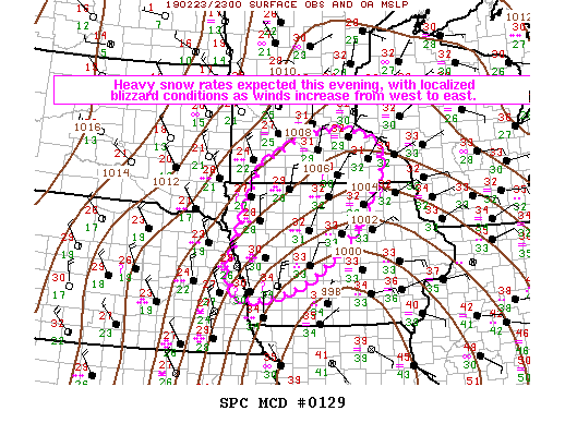
   SUMMARY...Heavy snow rates of 1-2"/hour (locally greater) are
   expected into this evening, with localized blizzard conditions
   possible later this evening as winds increase from west to east.

   DISCUSSION...Latest surface analysis depicts a deepening cyclone
   centered near Kansas City at 23Z. WV imagery shows a well-developed
   dry slot moving into southern IA, with thunderstorms noted on its
   leading edge. Very strong deep-layer ascent to the northwest of the
   low track is resulting in heavy snowfall rates in excess of 1"/hour
   across eastern NE, with occasional blizzard conditions. The
   rain/snow line has advanced through the Omaha area within the last
   1-2 hours, with portions of northwest IA beginning to transition to
   snow.

   As the cyclone moves northeastward this evening and thermal profiles
   cool due to strong ascent and increasing cold advection, heavy snow
   will spread into a larger portion of central/northern IA and
   southern MN. Snowfall rates of 1-2"/hour (locally higher) will
   continue through the evening, with some thundersnow possible as
   convective elements that develop on the apex of the dry slot feed
   into the primary snow band.

   Blizzard conditions may also develop from west to east across this
   region later this evening as low-level northwesterly flow increases
   in response to the deepening surface low. While the increase in
   winds may tend to coincide with decreasing snowfall rates on the
   backside of the precipitation shield, increasing cold advection will
   result in less water content with the remaining snowfall, resulting
   in a greater tendency for reduced visibility due to blowing snow.

   ..Dean.. 02/23/2019

   ...Please see www.spc.noaa.gov for graphic product...

   ATTN...WFO...ARX...MPX...DMX...FSD...OAX...

   LAT...LON   41669637 43019591 43879552 44499424 44619302 44329224
               43819214 43319242 42629283 41949356 41489425 41259476
               41169521 41089563 41169618 41669637
|
|
Top/All Mesoscale Discussions/Forecast Products/Home
|
|


