|
| Mesoscale Discussion 368 |
|
< Previous MD Next MD >
|
|
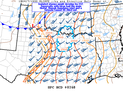
   Mesoscale Discussion 0368
   NWS Storm Prediction Center Norman OK
   0330 PM CDT Wed Apr 17 2019

   Areas affected...north central Texas through extreme southern
   Oklahoma

   Concerning...Severe potential...Watch possible

   Valid 172030Z - 172230Z

   Probability of Watch Issuance...60 percent

   SUMMARY...Trends are being monitored for development of supercells
   by 22Z over north central TX. Very large hail appears to be the main
   threat, but isolated damaging wind and a tornado are also possible.

   DISCUSSION...The dryline continues to mix eastward into western
   portion of north central TX this afternoon. Diabatic warming within
   the downstream warm sector, steep (8-8.5 C/km) mid-level lapse rates
   and dewpoints in the low 60s F have contributed to a corridor of
   moderate instability with 2000-2500 J/kg MLCAPE. Water vapor imagery
   shows a zone of mid-upper level drying/subsidence spreading into
   north central TX in wake of a leading shortwave trough. The
   subsidence and a remnant capping inversion within base of the
   elevated mixed layer (sampled by the 18Z Fort Worth RAOB) lends
   uncertainty to the timing extent of thunderstorm initiation this
   afternoon. However, it remains possible that at least a couple of
   storms might initiate along the dryline where strong convergence and
   deep mixing through the inversion layer exists. Should the storms
   develop, effective bulk shear from 45-50 kt would support supercells
   with very large hail the main threat. Low-level shear and size of
   0-1 km hodographs will remain relatively modest which should limit
   overall tornado threat. However, a tornado or two cannot be ruled
   out.

   ..Dial/Grams.. 04/17/2019

   ...Please see www.spc.noaa.gov for graphic product...

   ATTN...WFO...FWD...OUN...

   LAT...LON   34519727 34079675 32669706 32299817 32869823 33449825
               34189803 34519727
|
|
Top/All Mesoscale Discussions/Forecast Products/Home
|
|


 @NWSSPC