|
| Mesoscale Discussion 761 |
|
< Previous MD Next MD >
|
|
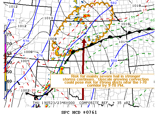
   Mesoscale Discussion 0761
   NWS Storm Prediction Center Norman OK
   0707 PM CDT Thu May 23 2019

   Areas affected...Much of western through north central Kansas into
   southeastern Nebraska

   Concerning...Severe Thunderstorm Watch 220...

   Valid 240007Z - 240130Z

   The severe weather threat for Severe Thunderstorm Watch 220
   continues.

   SUMMARY...Scattered storms may pose a risk for severe hail into this
   evening.  At least some increase in potential for strong surface
   gusts could develop near the Interstate 70 corridor of central
   Kansas by 9-10 PM CDT.  It is not certain that a new severe weather
   watch will be needed into portions of southern Nebraska, but trends
   will continue to be monitored for this possibility.

   DISCUSSION...Beneath broadly difluent mid/upper flow, strong
   low-level warm advection (focused generally near 850 mb) continues
   to support considerable scattered thunderstorm development across
   western through north central Kansas and south central Nebraska.
   This is occurring above seasonably cool to cold surface-based air to
   the north of a stalled frontal zone, but a southerly return flow of
   moisture above the front is contributing to weak to moderate
   elevated instability, in the presence of strong cloud-bearing layer
   shear.  Stronger convection is generally remaining discrete in
   nature as it develops northeastward and eastward toward southern
   portions of the mid Missouri Valley.  However, it appears possible
   that a strengthening southerly 850 mb jet (30-40+ kt) could provide
   the support and focus for upscale growing convection near the
   Interstate 70 corridor of north central Kansas toward 02-03z.

   ..Kerr.. 05/24/2019

   ...Please see www.spc.noaa.gov for graphic product...

   ATTN...WFO...OAX...TOP...ICT...GID...DDC...GLD...

   LAT...LON   38300153 39420092 40939906 41109619 39359660 38159866
               37480105 38300153
|
|
Top/All Mesoscale Discussions/Forecast Products/Home
|
|


 @NWSSPC