|
| Mesoscale Discussion 809 |
|
< Previous MD Next MD >
|
|
Mesoscale Discussion 0809
NWS Storm Prediction Center Norman OK
1209 PM CDT Sun May 26 2019
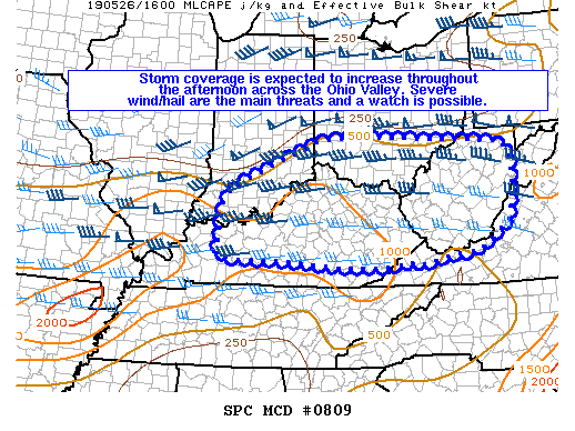
Areas affected...Portions of the Ohio Valley
Concerning...Severe potential...Watch possible
Valid 261709Z - 261845Z
Probability of Watch Issuance...60 percent
SUMMARY...Storm coverage is expected to increase across portions of
the Ohio Valley this afternoon/evening ahead of MCV now located in
southern Illinois. Severe wind and hail are the main threats and a
severe thunderstorm watch issuance is possible.
DISCUSSION...Storm coverage will increase across portions of the
Ohio Valley this afternoon and evening. Visible satellite imagery
shows a building Cu field across the region with a MCV and
associated showers/thunderstorms in southern Illinois. Temperatures
have warmed into the 80s with dewpoints in the mid 60s to low 70s
helping to increase MLCAPE to 1000-1500 J/kg per mesoanalysis. A
shortwave trough and increased mid-level flow will traverse over the
Ohio Valley this afternoon/evening, helping to spread forcing for
ascent and increasing shear over the region.
Multi-cellular clusters and isolated supercells are likely to
develop within this warm/moist/unstable environment. Given the
warming boundary layer, low-level lapse rates will steepen and
increase the potential for damaging wind gusts. Severe hail is also
possible, but mid-level lapse rates are marginal. While thunderstorm
coverage should increase, there is still some uncertainty regarding
severe coverage and upscale organization that would increase the
severe threat. However, severe thunderstorm coverage should be
sufficient enough to warrant a severe thunderstorm watch.
..Nauslar/Thompson.. 05/26/2019
...Please see www.spc.noaa.gov for graphic product...
ATTN...WFO...LWX...RNK...PBZ...RLX...MRX...JKL...ILN...LMK...
IND...PAH...
LAT...LON 38288718 38568700 38908634 39548474 39658386 39538140
39498058 39427994 39157966 38447967 37807982 37248060
37188117 36988219 37078239 36988304 37008425 37078506
37148599 37148673 37218730 37598728 38288718
|
|
Top/All Mesoscale Discussions/Forecast Products/Home
|
|


 @NWSSPC