|
| Mesoscale Discussion 853 |
|
< Previous MD Next MD >
|
|
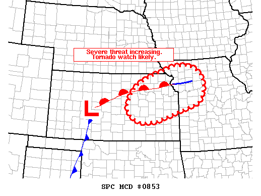
   Mesoscale Discussion 0853
   NWS Storm Prediction Center Norman OK
   1204 PM CDT Tue May 28 2019

   Areas affected...portions of eastern KS into northwest MO

   Concerning...Severe potential...Tornado Watch likely

   Valid 281704Z - 281830Z

   Probability of Watch Issuance...80 percent

   SUMMARY...Severe threat rapidly increasing early this afternoon. A
   tornado watch will likely be needed in the next hour.

   DISCUSSION...A cluster of storms over northeast KS persists early
   this afternoon. These storms are tracking northeast and are likely
   still elevated as MLCIN is still in place per 16z mesoanalysis.
   Nevertheless, severe hail was reported in the last 30 minutes in
   Marion County, KS given a supportive environment above the EML where
   lapse rates greater than 7.5 C/km were sampled in 12z regional RAOBs
   and given effective shear greater than 45 kt across the region.

   Forecast soundings suggest midlevel capping should erode by 18z and
   additional convection is expected to develop in the vicinity of the
   warm front and across the warm sector over parts of northeast KS.
   Meanwhile, cluster of ongoing storms may outpace any northward
   advancement of the warm front and become elevated over southeast NE
   into far northeast KS and northwest MO, posing mainly a large hail
   threat. If any of the cells with the current cluster become surface
   based and latch on to the warm front, the cells will pose a tornado
   threat due to enhancement of low level shear by the warm front.
   Additional development behind and to the south of this cluster may
   initially be semi-discrete supercells posing a threat for tornadoes,
   large hail and damaging wind. Given only modest low level
   directional shear, and deep layer southwesterly flow through much of
   the column, some upscale growth potential will exist with clusters
   or bowing segments possible. A watch will likely be needed in the
   next hour or so.

   ..Leitman/Thompson.. 05/28/2019

   ...Please see www.spc.noaa.gov for graphic product...

   ATTN...WFO...EAX...OAX...TOP...ICT...

   LAT...LON   38379438 37899584 37819674 37989717 38249750 38639753
               39039738 39479702 39829634 40319481 40329400 40139356
               39819327 39369314 38969327 38649353 38379438
|
|
Top/All Mesoscale Discussions/Forecast Products/Home
|
|


 @NWSSPC