Mesoscale Discussion 1027
NWS Storm Prediction Center Norman OK
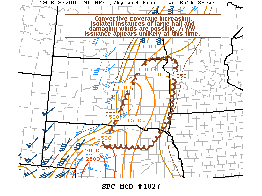
0347 PM CDT Sat Jun 08 2019
Areas affected...Portions of northern Nebraska into eastern South
Dakota
Concerning...Severe potential...Watch unlikely
Valid 082047Z - 082215Z
Probability of Watch Issuance...20 percent
SUMMARY...Scattered storm development is expected to continue across
the area for the next few hours. Isolated damaging wind gusts and
large hail may occur with the most organized and sustained storms.
Given the isolated nature of the severe threat, a WW issuance is not
currently anticipated.
DISCUSSION...Scattered storms have been developing along and behind
the cold front within the past couple of hours given the
overspreading of deeper-layer ascent aloft with the ejecting of a
mid-level shortwave trough into the northern Plains. Modest buoyancy
is in place, with over 1000 J/kg MLCAPE noted. Nonetheless, much of
the area has experienced quite a bit of cloud cover, hampering
further destabilization. In addition, vertical wind profiles
demonstrate weak flow magnitudes, with a veer-back-veer profile
below 700 mb, suggesting somewhat unfavorable kinematics for a more
widespread severe threat, especially with much of the convection
already undercut by the cold front. A few of the more
organized/longer-lived cells may produce a few severe hail stones
and damaging wind gusts given the modest lapse rates in place, but
the severe threat is expected to remain isolated at best, with a WW
issuance not expected.
..Squitieri/Thompson.. 06/08/2019
...Please see www.spc.noaa.gov for graphic product...
ATTN...WFO...MPX...FGF...FSD...OAX...ABR...LBF...UNR...
LAT...LON 42130047 42839987 44259909 45169852 45909780 45929604
43379656 42089778 42130047
|


 @NWSSPC