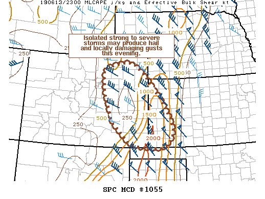
   Mesoscale Discussion 1055
   NWS Storm Prediction Center Norman OK
   0658 PM CDT Thu Jun 13 2019

   Areas affected...eastern CO into western KS

   Concerning...Severe potential...Watch unlikely

   Valid 132358Z - 140130Z

   Probability of Watch Issuance...20 percent

   SUMMARY...Isolated storms may produce strong gusts and hail the next
   few hours across parts of eastern CO and perhaps into western KS.

   DISCUSSION...A couple of isolated, but intense storms have developed
   over portions of northeast CO this evening. MRMS MESH indicated
   these cells may be producing hail near 1 inch in diameter.
   Additionally, given a dry sub-cloud layer with dewpoints generally
   in the 40s, some potential for strong outflow winds exists. Further
   east toward western KS, dewpoints increase to the low to mid 50s as
   modest boundary layer moisture streams northward on 20-30 kt
   southerly low level flow. If storms can remain semi-organized as
   they track southeastward toward a more unstable airmass where a
   modestly increasing low level jet develops through the evening, some
   isolated potential for strong to severe storms will persist through
   the evening hours. That being said, the 00z RAOB from DDC does not
   instill a great deal of confidence in the evolution of a greater
   severe threat given strong MLCIN.

   Otherwise, as the boundary layer continues to cool with loss of
   daytime heating, severe wind potential should decrease in the
   absence of better organized cells. Some marginal hail threat may
   persist given modestly steep midlevel lapse rates and favorable deep
   layer shear, but this is contingent on sustained convection
   continuing southeastward with time. Given the overall isolated and
   somewhat conditional nature of the threat, a watch is not expected
   at this time.

   ..Leitman/Guyer.. 06/13/2019

   ...Please see www.spc.noaa.gov for graphic product...

   ATTN...WFO...DDC...GLD...AMA...PUB...BOU...

   LAT...LON   38240079 37640062 37210088 36970137 37040249 37200310
               38060398 39360448 40430452 40680363 40700293 40150226
               39060129 38240079
|


 @NWSSPC