Mesoscale Discussion 1691
NWS Storm Prediction Center Norman OK
0356 PM CDT Sat Aug 10 2019
Areas affected...Southern MN...Western/central IA
Concerning...Severe potential...Watch unlikely
Valid 102056Z - 102300Z
Probability of Watch Issuance...20 percent
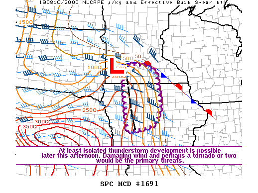
SUMMARY...At least isolated thunderstorm development is possible
this afternoon. The strongest cells will be capable of producing
locally damaging wind and perhaps a tornado or two. Due to
uncertainty regarding the coverage of the threat, watch issuance is
currently considered unlikely.
DISCUSSION...The latest surface analysis depicts a weak surface low
across southwest MN, with a surface boundary extending eastward
across southern MN and then southeastward into northeastern IA. A
zone of weakly confluent flow, likely related to differential
heating, is also noted extending south of the low into western IA.
Widespread cloudiness has limited heating across the region, but
rich low-level moisture is supporting MLCAPE ranging from 500 J/kg
across the eastern portion of the MCD area to around 2000 J/kg
across the western portion. Thunderstorm development will be
possible later this afternoon near these surface features, with the
greatest threat likely near the confluence zone across
northwest/north-central IA where somewhat greater destabilization is
occurring.
Moderate mid/upper-level flow is resulting in effective shear of
40-50 kt across the region, more than sufficient for organized storm
structures (including supercells) should convection develop. Warm
midlevel temperatures and generally weak midlevel lapse rates are
likely to mitigate the severe threat (especially hail) to some
extent, but eventual development of one or two supercells is
possible. Locally damaging wind would be the primary threat, but a
tornado or two would also be possible, given favorable
boundary-layer moisture and marginally supportive low-level shear
profiles.
Watch issuance is currently considered unlikely due to uncertainty
regarding the number of storms that can develop across this region.
However, this will be re-evaluated if multiple organized cells
appear imminent.
..Dean/Grams.. 08/10/2019
...Please see www.spc.noaa.gov for graphic product...
ATTN...WFO...MPX...DMX...FSD...
LAT...LON 41379495 42219508 43389523 44169532 44389491 44339399
44029329 42499301 41769330 41539377 41379495
|


 @NWSSPC