|
| Mesoscale Discussion 1705 |
|
< Previous MD Next MD >
|
|
Mesoscale Discussion 1705
NWS Storm Prediction Center Norman OK
0551 PM CDT Sun Aug 11 2019
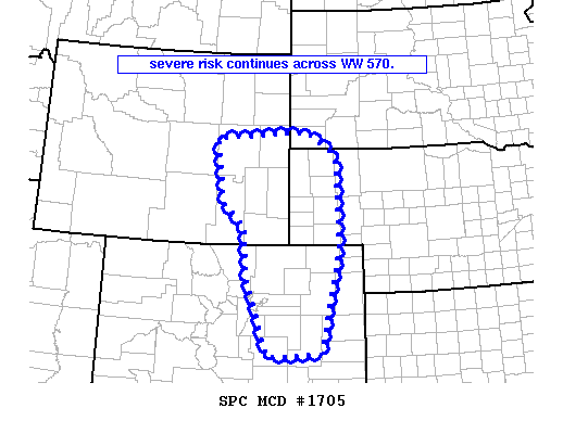
Areas affected...eastern Wyoming/eastern Colorado into the Nebraska
Panhandle
Concerning...Severe Thunderstorm Watch 570...
Valid 112251Z - 120045Z
The severe weather threat for Severe Thunderstorm Watch 570
continues.
SUMMARY...Strong/locally severe thunderstorms continue across WW
570.
DISCUSSION...Latest radar loop shows widespread thunderstorms --
including a few well-organized, rotating updrafts -- occurring over
the central high Plains region. The storms are evolving near
multiple/complex boundary interactions across the area. With
low-level east-southeast flow advecting moist low-level air (60s
dewpoints) into the high Plains fueling the convection, expect
storms to continue for several hours.
A couple of brief tornadoes have been reported over the past couple
of hours, and large hail is also indicated with a couple of the most
intense updrafts. These risks -- along with potential for locally
damaging wind gusts -- are ongoing. With time, storms should grow
upscale, and spread eastward into/across southwestern Nebraska and
northwestern Kansas -- where Tornado Watch 572 is currently in
effect.
..Goss/Hart.. 08/11/2019
...Please see www.spc.noaa.gov for graphic product...
ATTN...WFO...LBF...UNR...GLD...PUB...BOU...CYS...
LAT...LON 38770317 38690459 40320519 41390525 41840585 43190606
43350355 42880275 40940268 38770317
|
|
Top/All Mesoscale Discussions/Forecast Products/Home
|
|


 @NWSSPC