|
| Mesoscale Discussion 1737 |
|
< Previous MD Next MD >
|
|
Mesoscale Discussion 1737
NWS Storm Prediction Center Norman OK
0310 PM CDT Wed Aug 14 2019
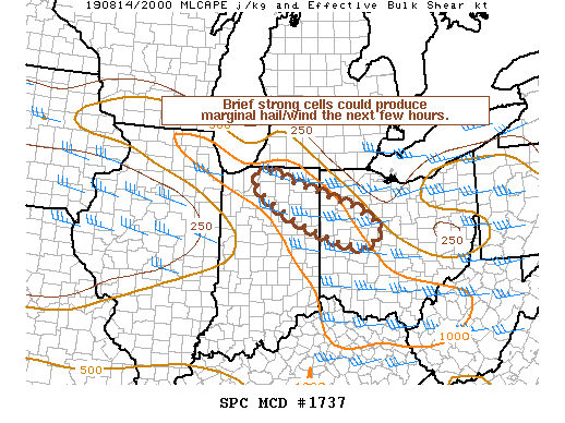
Areas affected...portions of northeast IN into northwest OH
Concerning...Severe potential...Watch unlikely
Valid 142010Z - 142145Z
Probability of Watch Issuance...5 percent
SUMMARY...A couple of strong storms could produce marginal hail and
gusty winds through the remainder of the afternoon.
DISCUSSION...Isolated thunderstorms have increased in intensity this
afternoon from Marshall to Allen counties in IN and Van Wert County
in OH. The most intense cell currently is near Fort Wayne, where a
cell has interacted with an outflow boundary from a previous
decaying cell. This cell has shown some weak rotation, which has
probably been enhanced by the interaction with the aforementioned
boundary. Some strong gusts and marginal hail are possible with
strongest cells this afternoon given around 30 kt effective shear
and a weak mid/upper level impulse migrating through westerly deep
layer flow. Midlevel lapse rates will remain poor and limit severe
hail potential. Steep low level lapse rates and a deeply-mixed
sub-cloud layer will favor some stronger downdrafts and gusty winds.
Overall, the threat should remain limited in intensity and coverage
and a watch is not expected.
..Leitman/Grams.. 08/14/2019
...Please see www.spc.noaa.gov for graphic product...
ATTN...WFO...CLE...ILN...IWX...
LAT...LON 41638654 41658622 41338515 40908383 40548322 40338326
40108359 40188419 40658542 41188634 41468661 41638654
|
|
Top/All Mesoscale Discussions/Forecast Products/Home
|
|


 @NWSSPC