|
| Mesoscale Discussion 1960 |
|
< Previous MD Next MD >
|
|
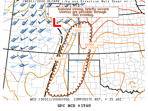
   Mesoscale Discussion 1960
   NWS Storm Prediction Center Norman OK
   0334 PM CDT Wed Sep 11 2019

   Areas affected...southeast CO...southwest KS...portions of eastern
   NM into the OK/TX Panhandles

   Concerning...Severe potential...Watch unlikely

   Valid 112034Z - 112230Z

   Probability of Watch Issuance...5 percent

   SUMMARY...A few strong storms are possible through early evening.
   Isolated strong wind gusts will be the main concern, though the
   sparse nature of the threat should preclude watch issuance.

   DISCUSSION...Isolated thunderstorms have developed this afternoon in
   convergent low level flow along a surface trough/dryline extending
   southward from a low near the Palmer Divide into eastern NM. Strong
   heating and moderate moisture (surface dew points low/mid 60s F) has
   resulted in a corridor of 1000-2000 J/kg MLCAPE and modest effective
   shear, supporting a few strong cells. This is especially the case
   from far northeast NM into the northern TX Panhandle northward into
   southeast CO/southwest KS, where effective shear near 30 kt and
   midlevel lapse rates approaching 7-7.5 C/km will foster better
   organized updrafts. While this could result in some small hail,
   sporadic strong downburst winds are more likely given very steep low
   level lapse rates and inverted-v type low level thermodynamic
   profiles. While a couple of storms could briefly reach severe
   criteria, the overall threat is expected to be sparse and
   short-lived with any given cell.

   ..Leitman/Hart.. 09/11/2019

   ...Please see www.spc.noaa.gov for graphic product...

   ATTN...WFO...DDC...GLD...LUB...AMA...PUB...ABQ...

   LAT...LON   34080250 33810328 33770422 33780467 33920477 34350487
               36110411 37430360 38800292 39190253 39400193 39490116
               39250083 38890083 37250103 36040134 34880178 34230233
               34080250
|
|
Top/All Mesoscale Discussions/Forecast Products/Home
|
|


 @NWSSPC