|
| Mesoscale Discussion 2183 |
|
< Previous MD Next MD >
|
|
Mesoscale Discussion 2183
NWS Storm Prediction Center Norman OK
0136 AM CST Sun Dec 01 2019
Areas affected...Portions of the Upper Peninsula of MI and
northern/central Lower MI
Concerning...Winter mixed precipitation
Valid 010736Z - 011330Z
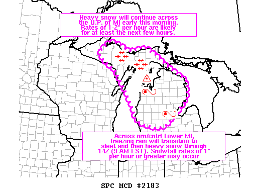
SUMMARY...Heavy snow will continue across the U.P. of Michigan early
this morning. Rates of 1-2 inches per hour are likely for at least
the next few hours. Across northern/central Lower Michigan, freezing
rain will transition to sleet and then heavy snow through 14Z (9 AM
EST). Snowfall rates of 1 inch per hour or greater may occur.
DISCUSSION...A pronounced upper low over IA will continue eastward
across the Midwest early this morning. Robust large-scale ascent
associated with the exit region of a mid/upper-level jet will
likewise shift eastward across the upper Great Lakes region over the
next several hours. A snow band oriented generally east-west across
the U.P. of MI should persist for at least the next few hours, with
snowfall rates of 1-2 inches per hour likely as some lake
enhancement occurs given the east-northeasterly fetch off of Lake
Superior.
Across northern Lower MI, a couple of 07Z surface observations show
light freezing rain occurring. This is due to an elevated warm nose
centered around 850-700 mb per RAP forecast soundings. This
low-level inversion is forecast to gradually erode from west to east
across Lower MI over the next few hours as temperatures aloft cool
with the approach of the upper low. A transition from light freezing
rain to sleet, and eventually snow is expected. Strong lift will
occur through the depth of the dendritic growth zone, and snowfall
rates of 1 inch per hour or greater appear likely across parts of
northern/central Lower MI by 11-12Z (6-7 AM EST) and after.
..Gleason.. 12/01/2019
...Please see www.spc.noaa.gov for graphic product...
ATTN...WFO...DTX...APX...GRR...MQT...GRB...
LAT...LON 45668781 46288890 46608879 46978827 46878756 46688734
46568689 46618646 46768598 46388526 45808440 45568403
45358354 45098329 44738331 44378334 43898385 43218467
43098523 43278605 43518652 43858661 44918729 45668781
|
|
Top/All Mesoscale Discussions/Forecast Products/Home
|
|


 @NWSSPC