|
| Mesoscale Discussion 3 |
|
< Previous MD Next MD >
|
|
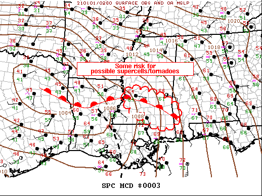
   Mesoscale Discussion 0003
   NWS Storm Prediction Center Norman OK
   0931 PM CST Thu Dec 31 2020

   Areas affected...Central/Southeast Mississippi...Southwest Alabama

   Concerning...Severe potential...Watch possible

   Valid 010331Z - 010530Z

   Probability of Watch Issuance...40 percent

   SUMMARY...Some risk for tornadoes will focus along the warm front
   over the next several hours. Even so, it's not clear a tornado watch
   is warranted.

   DISCUSSION...Surface warm front has lifted into central MS, arcing
   southeast into southwest AL. Warm sector is characterized by
   mid-upper 60s dew points but lapse rates are marginal and this is
   limiting buoyancy across this region. 00z sounding from LIX supports
   this with deep-layer lapse rates on the order of 5.5 C/km, though
   strongly sheared with more than enough flow for sustaining
   supercells. Convection has struggled to organize across the lower MS
   Valley into the central Gulf coast region, partly due to the lack of
   stronger forcing which is currently ejecting northeast across TX.
   Additionally, substantial mid-level drying has overspread the warm
   sector and this may be inhibiting more substantial updrafts,
   especially given the weak low-level convergence. For these reasons,
   if sustained supercells materialize they will likely focus along the
   warm front where low-level convergence is greater. Given the dearth
   of robust convection at this time it's not clear a new tornado watch
   will be warranted.

   ..Darrow/Bunting.. 01/01/2021

   ...Please see www.spc.noaa.gov for graphic product...

   ATTN...WFO...MOB...JAN...

   LAT...LON   32619059 32318917 31618813 30878863 31098970 32029097
               32619059
|
|
Top/All Mesoscale Discussions/Forecast Products/Home
|
|


 @NWSSPC