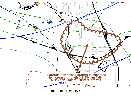
   Mesoscale Discussion 0057
   NWS Storm Prediction Center Norman OK
   1246 PM CST Sat Feb 06 2021

   Areas affected...Parts of the central Florida Peninsula

   Concerning...Severe potential...Watch possible

   Valid 061846Z - 062115Z

   Probability of Watch Issuance...40 percent

   SUMMARY...Increasingly strong, scattered thunderstorm development is
   possible through 3-6 PM EST, accompanied by at least some risk for
   severe weather.  It is not yet clear that a severe weather watch
   will be needed, at least in the near term, but trends will continue
   to be monitored for this possibility.

   DISCUSSION...Moistening on modest south-southwesterly low-level
   flow, including 20-30 kt around the 850 mb level, is contributing to
   increasing CAPE in the presence of modestly steep lower/mid
   tropospheric lapse rates across much of central and southern
   Florida.  To the north (roughly) of the Tampa, Avon Park, and Vero
   Beach areas, this is still generally above a residually cool and
   stable near-surface layer, but boundary-layer modification is
   ongoing.  Breaks in cloud cover should allow for continued surface
   heating through the afternoon, and, beneath broadly cyclonic,
   southwesterly mid-level flow, some further strengthening of 850 mb
   flow to 30+ kt is forecast.  As this occurs, veering of surface
   winds to an increasingly southerly component is expected to be
   accompanied by surface dew point increases into the upper 60s/near
   70f.

   While warm layers aloft are tending to suppress thunderstorm
   development, forecast soundings suggest that the low-level warming
   and moistening will increasingly overcome this inhibition this
   afternoon.  Aided by large-scale ascent associated with warm
   advection, and coinciding with an increasingly conducive environment
   to boundary-layer based thunderstorm development, isolated supercell
   structures appear possible.  Deep-layer sheer is already sufficient,
   and with some further enlargement of low-level hodographs through
   20-23Z, potential for at least isolated storms capable of producing
   severe hail, locally strong surface gusts and some risk for a
   tornado or two, probably will increase.

   ..Kerr/Hart.. 02/06/2021

   ...Please see www.spc.noaa.gov for graphic product...

   ATTN...WFO...MLB...TBW...JAX...

   LAT...LON   29088230 28658162 28227998 27598035 27168165 27548256
               28248297 29088230
|


 @NWSSPC