|
| Mesoscale Discussion 58 |
|
< Previous MD Next MD >
|
|
Mesoscale Discussion 0058
NWS Storm Prediction Center Norman OK
0249 PM CST Sat Feb 06 2021
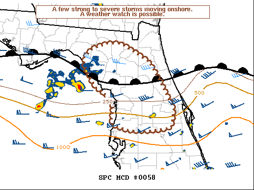
Areas affected...Central/Northern Florida Peninsula
Concerning...Severe potential...Watch possible
Valid 062049Z - 062215Z
Probability of Watch Issuance...40 percent
SUMMARY...Strong to severe storms moving onshore across the western
coast of Florida may pose a risk for damaging wind gusts, hail and a
tornado over the next few hours.
DISCUSSION...Several strong storms including a few supercells are
approaching the western coast of the central/ northern Florida
Peninsula. These storms are moving along a northward moving warm
front located near Ocala. Instability north of the front remains
elevated and weaker than to the south where surface heating and
dewpoints in the 60s have contributed to 500-1000 J/kg of MLCAPE.
Despite the limited buoyancy along and north of the front, severe
weather appears possible with the ongoing and additional convection
this evening. Deep-layer shear of greater than 50 kts will support
supercells capable of isolated large hail north of the front.
Additional surface based destabilization will be possible with
low-level warm advection as the front continue to move northward
this evening. The greater buoyancy and enhanced low-level shear
along the front will likely result in an increased severe risk as
storms become progressively more surface based. The primary hazards
will be damaging wind gusts, hail, and perhaps a tornado.
..Lyons.. 02/06/2021
...Please see www.spc.noaa.gov for graphic product...
ATTN...WFO...MLB...TBW...JAX...TAE...
LAT...LON 29678350 29878358 30148334 30288288 30268250 29838174
29278140 28708108 28258117 28188170 28188230 28348277
28588274 28778272 28888277 29108300 29188319 29368331
29678350
|
|
Top/All Mesoscale Discussions/Forecast Products/Home
|
|


 @NWSSPC