|
| Mesoscale Discussion 76 |
|
< Previous MD Next MD >
|
|
Mesoscale Discussion 0076
NWS Storm Prediction Center Norman OK
0902 AM CST Sat Feb 13 2021
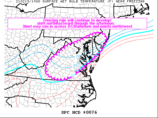
Areas affected...portions of the Mid-Atlantic
Concerning...Freezing rain
Valid 131502Z - 132100Z
SUMMARY...Areas of freezing rain and occasional sleet will impact
much of the Mid-Atlantic through early afternoon.
DISCUSSION...A broad area of ascent/isentropic lift atop a shallow
cold airmass continues to contribute to widespread freezing rain at
this time. The freezing rain is reportedly mixing with sleet at
times across the DC/Baltimore MD areas, though a transition to more
freezing rain should occur in that area over time as models indicate
warm advection in the H7-H85 layer. Precipitation rates may
approach 0.05 inch/hour at times beneath heavier precipitation
bands. The general regime should persist through early afternoon,
with a general northeastward expansion of the precipitation shield
toward Delaware/southern New Jersey and the Philadelphia area over
the next couple hours or so. Several models/CAMs shift
precipitation out of much of Virginia and western Maryland around
21Z.
..Cook.. 02/13/2021
...Please see www.spc.noaa.gov for graphic product...
ATTN...WFO...PHI...AKQ...CTP...LWX...RNK...
LAT...LON 39087815 39347734 39967564 40067489 39757443 39527439
39407450 38747502 37587660 36827786 36617874 36767934
36957986 37308004 37827988 39087815
|
|
Top/All Mesoscale Discussions/Forecast Products/Home
|
|


 @NWSSPC