|
| Mesoscale Discussion 82 |
|
< Previous MD Next MD >
|
|
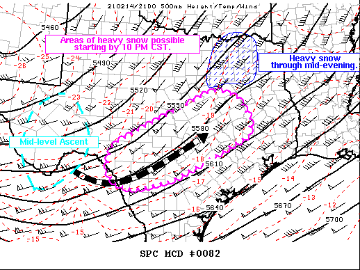
   Mesoscale Discussion 0082
   NWS Storm Prediction Center Norman OK
   0704 PM CST Sun Feb 14 2021

   Areas affected...Portions of Texas Hill Country into Southeast Texas

   Concerning...Heavy snow

   Valid 150104Z - 150700Z

   SUMMARY...Pockets of moderate to heavy snow are possible in parts of
   the DFW metro and eastward in the short term. The next area of heavy
   snow to develop will likely be within the Edwards Plateau perhaps by
   8-10 PM CST. This heavy snow will develop eastward into Southeast
   Texas through the evening and overnight.

   DISCUSSION...Current water vapor imagery shows another area of
   mid-level ascent moving through the Big Bend region. This ascent is
   forecast to pivot through the base of the broad upper-level trough
   as it moves east. MRMS radar imagery shows heavier bands of
   precipitation developing in Mexico that should begin to move into
   the Edwards Plateau within the next 1-3 hours. 1 inch per hour
   snowfall rates are possible as the favorable lift within the
   dendritic growth layer moves through the region.

   A band of moderate to heavy snow now moving east through the DFW
   metro area will continue to bring around 1 inch per hour rates.
   However, this is expected to decrease with time as the more
   favorable synoptic ascent shifts to the south.

   ..Wendt.. 02/15/2021

   ...Please see www.spc.noaa.gov for graphic product...

   ATTN...WFO...HGX...FWD...EWX...SJT...

   LAT...LON   29310099 29760093 30140079 30769962 31429820 31989708
               32019670 31799599 31089549 30539554 29999663 29099846
               28729991 28850060 29190093 29310099
|
|
Top/All Mesoscale Discussions/Forecast Products/Home
|
|


 @NWSSPC