Mesoscale Discussion 0094
NWS Storm Prediction Center Norman OK
0308 PM CST Mon Feb 15 2021
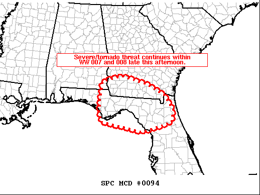
Areas affected...the eastern half of the Florida Panhandle into
adjacent southern Georgia and northern Florida
Concerning...Tornado Watch 7...8...
Valid 152108Z - 152315Z
The severe weather threat for Tornado Watch 7, 8 continues.
SUMMARY...Widespread storms, and local severe weather threat,
continues within Tornado Watches 007 and 008.
DISCUSSION...Latest radar loop shows a band of strong storms
crossing central portions of the Florida Panhandle, and far
southeastern Alabama near the Alabama/Georgia border -- within WW
007. Other/more isolated storms continue farther east, into
northern portions of the Florida Peninsula -- within WW 008.
The boundary layer across WW 007 has been slow to destabilize
northward, and with increasingly widespread precipitation
moving/spreading across the remainder of the WW area, little
additional surface-based destabilization is expected before storms
exit the watch over the next hour to hour and a half. Until then,
damaging winds will remain the primary severe risk, with a tornado
or two still possible.
Meanwhile, a much more favorable thermodynamic environment persists
across roughly the southern half of WW 008, but flow -- though
gradually increasing -- remains weaker than areas farther west.
Still, gusty/damaging winds and a tornado or two remain possible,
with risk to begin diminishing gradually into early evening beyond
the diurnal instability peak.
..Goss.. 02/15/2021
...Please see www.spc.noaa.gov for graphic product...
ATTN...WFO...TBW...JAX...TAE...
LAT...LON 29978546 30618541 31368533 31658434 31228282 30738202
30098154 29498164 29078318 29538537 29978546
|


 @NWSSPC