|
| Mesoscale Discussion 102 |
|
< Previous MD Next MD >
|
|
Mesoscale Discussion 0102
NWS Storm Prediction Center Norman OK
0315 PM CST Tue Feb 16 2021
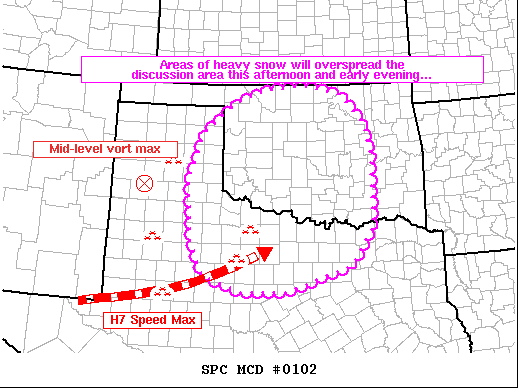
Areas affected...Oklahoma and much of north Texas
Concerning...Heavy snow
Valid 162115Z - 170115Z
SUMMARY...Areas of moderate to locally heavy snow will continue to
expand northeastward across the discussion area from western north
Texas this afternoon and evening. Rates of 1 inch per hour are
possible in heavier bands.
DISCUSSION...Lift associated with an ejecting mid-level wave over
New Mexico and an ejecting speed max across west-central Texas has
contributed to an expanding area of precipitation across the Texas
South Plains and western North Texas currently. Moderate to heavy
snow has been observed at Lubbock, Childress, and Hardeman County
over the past hour or so beneath heavier precipitation bands. The
precipitation was falling within nearly saturated mid-level
thermodynamic profiles observed via model soundings, and the
expectation is that low-level moistening will continue as
precipitation continues to expand in coverage. A warm layer
(approaching 0 deg C) was noted in profiles across portions of
western north Texas, which may foster occasional mixing with sleet
and even convective development especially on the southern extent of
the discussion area.
Over time, models support a general expansion of the precipitation
shield across much of the discussion area with potential for a
couple of areas of heavier precipitation - one across
north-central/central Oklahoma (near the US 412 corridor) and 2)
across southern Oklahoma, where isentropic lift (from convergent
850hPa flow) will contribute to heavier precipitation near the Red
River. Along the Red River, this increase in precipitation
intensity is expected to occur gradually through at least 02Z.
..Cook.. 02/16/2021
...Please see www.spc.noaa.gov for graphic product...
ATTN...WFO...TSA...FWD...OUN...SJT...LUB...AMA...
LAT...LON 32329945 32670044 33420080 34770089 35850053 36589962
36879877 36989769 36749668 36119608 35309589 34759589
33789588 32899650 32329827 32329945
|
|
Top/All Mesoscale Discussions/Forecast Products/Home
|
|


 @NWSSPC