Mesoscale Discussion 0209
NWS Storm Prediction Center Norman OK
0224 PM CDT Wed Mar 17 2021
Areas affected...Central AL
Concerning...Tornado Watch 29...33...
Valid 171924Z - 172100Z
The severe weather threat for Tornado Watch 29, 33 continues.
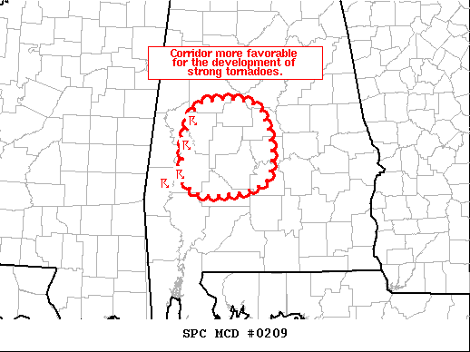
SUMMARY...A corridor more favorable for the development of strong
tornadoes may be evolving across central AL.
DISCUSSION...Radar imagery from BMX, GWX, and MOB continues to show
a cluster of supercells over west-central AL. The downstream air
mass is characterized by temperatures in the low/mid 70s and
dewpoints in the upper 60s. As noted in the recent BMX sounding,
this air mass is less buoyant than farther west (along the central
MS/AL border) where this cluster initially developed. However, in
contrast to the slightly less favorable thermodynamics, surface
winds here are more southeasterly, veering to southerly in the
low-levels, and then southwesterly farther aloft. This is resulting
in considerable low-level vertical shear. Recent VAD profile from
BMX sampled 350+ m2/s2 of 0-1 km storm-relative helicity. Given the
already organized character of these storms, potential exists for
the development of strong tornadoes if a more discrete nature can be
maintained.
..Mosier.. 03/17/2021
...Please see www.spc.noaa.gov for graphic product...
ATTN...WFO...BMX...MOB...
LAT...LON 32938782 33178747 33038674 32158666 31978763 32298791
32938782
|


 @NWSSPC