|
| Mesoscale Discussion 210 |
|
< Previous MD Next MD >
|

|
   Mesoscale Discussion 0210
   NWS Storm Prediction Center Norman OK
   0256 PM CDT Wed Mar 17 2021

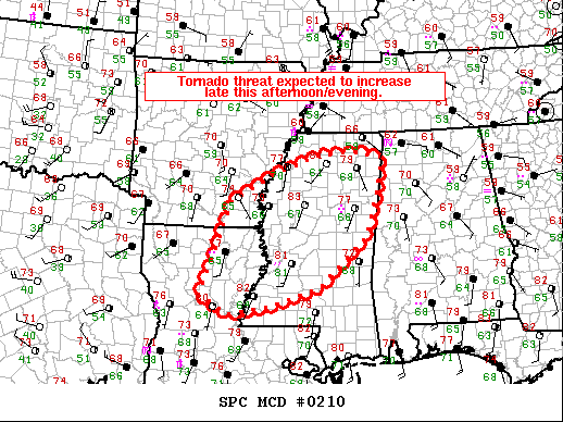
   Areas affected...Northeast Louisiana...southeast Arkansas and much
   of Mississippi.

   Concerning...Tornado Watch 32...

   Valid 171956Z - 172130Z

   The severe weather threat for Tornado Watch 32 continues.

   SUMMARY...The tornado threat is expected to increase late this
   afternoon/evening.

   DISCUSSION...Most of Mississippi is in a relative lull for
   convective coverage/intensity with more intense convection to the
   east with the stronger low-level jet and to the west near the
   surface trough. Within this area, significant clearing has allowed
   temperatures to warm into the low 80s with dewpoints in the upper
   60s yielding MLCAPE of 1500 to 2000 J/kg per SPC mesoanalysis. This
   strong surface heating has led to deep boundary layer mixing (as
   evident on the 18Z JAN RAOB) and as a result, surface flow has
   veered southwesterly across much of Mississippi which has reduced
   low-level directional shear significantly. However, despite this
   veered low-level flow, a widespread and potentially intense tornado
   threat is still expected late this afternoon/evening as the surface
   trough approaches.

   Low-level flow in proximity to this surface trough has started to
   back across southeast Arkansas and Louisiana. Expect this trend to
   continue as the boundary tightens in response to the ejecting upper
   trough. Evidence of this ejecting trough and the corresponding
   increase to the flow field can be seen on the KLCH VWP where 1km
   flow has strengthened by 20 kts (to near 60 knots) within the last
   hour. Expect this stronger low-level jet to overspread much of the
   warm sector by 22-00Z which should elongate low-level hodographs
   substantially.

   Expect multiple supercells to develop along this surface boundary in
   the next few hours and track northeastward through the late
   afternoon and into the evening hours. In response to the
   aforementioned instability and strengthening low-level shear, the
   12Z HREF shows widespread 4+ STP across much of Mississippi this
   afternoon/evening with some areas in excess of 6. This environment
   will support the potential for intense/long-track tornadoes through
   the late afternoon and evening hours.

   ..Bentley.. 03/17/2021

   ...Please see www.spc.noaa.gov for graphic product...

   ATTN...WFO...HUN...MEG...JAN...LIX...LZK...LCH...SHV...

   LAT...LON   31629262 32439230 33559193 34139085 34558968 34618884
               34478814 33798826 32818859 31788974 31409097 31249198
               31629262
|
|
Top/All Mesoscale Discussions/Forecast Products/Home
|
|


