Mesoscale Discussion 0346
NWS Storm Prediction Center Norman OK
0359 PM CDT Fri Apr 09 2021
Areas affected...Parts of central Texas
Concerning...Severe potential...Watch possible
Valid 092059Z - 092300Z
Probability of Watch Issuance...40 percent
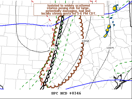
SUMMARY...Isolated to widely scattered intense thunderstorms
increasingly possible through 5-6 PM, accompanied by the risk for
large, potentially damaging, hail and locally strong surface gusts.
A severe weather watch may be needed within the next hour or so.
DISCUSSION...The deepening moist boundary layer has become strongly
unstable along/east of the dryline which is still just west of the
Interstate 35 corridor, across north central through central Texas.
As mid-level troughing begins to overspread this region, it appears
that cooling aloft is contributing to weakening of initially strong
mid-level inhibition. Initial attempts at thunderstorm development
may be underway to the west of the dryline, based on recent
satellite imagery, and isolated to widely scattered thunderstorm
development appears possible through 22-23Z.
Strongest deep-layer shear, beneath the high-level jet of
lower-latitude Pacific origin, is generally south of the Dallas-Fort
Worth Metroplex, between Waco and San Antonio, where potential for
supercells currently seems highest. This probably will be
accompanied by a risk for large, potentially damaging hail, and
locally strong surface gusts into early evening.
..Kerr/Thompson.. 04/09/2021
...Please see www.spc.noaa.gov for graphic product...
ATTN...WFO...HGX...FWD...EWX...
LAT...LON 32539781 32609689 30859676 29859735 29379815 29539867
29889878 30729831 32539781
|


 @NWSSPC