|
| Mesoscale Discussion 370 |
|
< Previous MD Next MD >
|
|
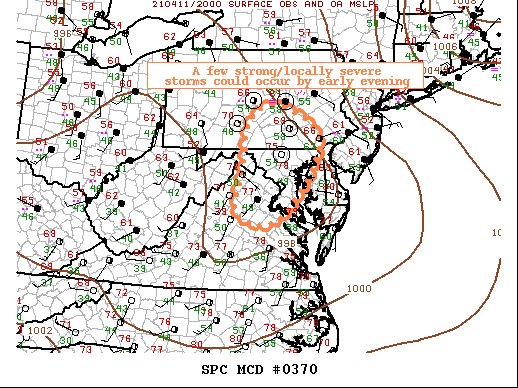
   Mesoscale Discussion 0370
   NWS Storm Prediction Center Norman OK
   0354 PM CDT Sun Apr 11 2021

   Areas affected...Northern Virginia...Maryland...southern
   Pennsylvania

   Concerning...Severe potential...Watch unlikely

   Valid 112054Z - 112300Z

   Probability of Watch Issuance...5 percent

   SUMMARY...A few strong to locally severe thunderstorms may develop
   through late afternoon/early evening, primarily across parts of
   northern Virginia and central Maryland into southern Pennsylvania.

   DISCUSSION...Convection has struggled to deepen this afternoon
   near/just ahead of an eastward-moving cold front, owing to factors
   such as limited boundary layer moisture and weak convergence owing
   to veered near-surface winds within the pre-frontal warm sector.
   While surface dewpoints continue to drop coincident with ample
   boundary layer mixing, a recent modest increase in convergence has
   been noted in vicinity of the front and near/just east of the Blue
   Ridge along with increasing cumuliform development.

   Additional development and convective intensification is still
   plausible through the late afternoon/early evening, particularly
   within a corridor across northern Virginia/DC vicinity/central
   Maryland into south-central Pennsylvania where low-level convergence
   should maximize in vicinity of surface low/triple point. Where
   thunderstorms are able to develop and sustain, a warm and well-mixed
   boundary layer would support the possibility of some strong/locally
   damaging wind gusts, aside from the possibility of some hail.

   ..Guyer/Thompson.. 04/11/2021

   ...Please see www.spc.noaa.gov for graphic product...

   ATTN...WFO...PHI...AKQ...CTP...LWX...

   LAT...LON   40707728 40537652 40027590 39337606 38087714 38137818
               38467834 39257810 40407794 40707728
|
|
Top/All Mesoscale Discussions/Forecast Products/Home
|
|


 @NWSSPC