Mesoscale Discussion 0376
NWS Storm Prediction Center Norman OK
0828 AM CDT Tue Apr 13 2021
Areas affected...portions of central/southern LA.
Concerning...Severe potential...Watch possible
Valid 131328Z - 131530Z
Probability of Watch Issuance...40 percent
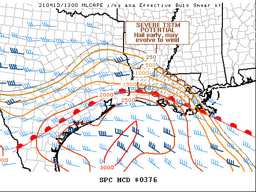
SUMMARY...Potential will increase through midday for severe
thunderstorms across the discussion area, with hail initially the
main concern. Damaging wind may become more of a threat with time
over south-central LA as the thunderstorms become better-organized
and shift southeastward.
DISCUSSION...Scattered thunderstorms in clusters have developed
during the past hour, mainly over portions of Beauregard, Allen,
Evangeline, and St. Landry Parishes, with a detached, loosely
organized arc of weaker convection farther north in central LA. The
main threat will be large hail for the next couple hours, but
late-morning/midday evolution into a cold-pool-driven MCS is
possible with strong-severe gusts.
This activity currently is occurring in a zone of elevated warm
advection and moisture transport, north of a marine/warm front
analyzed over southeast TX and extreme southern LA near a
HOU-LCH-HUM line. The 12Z LCH sounding, along that front, sampled
the upstream inflow layer well for the convection, with steep
midlevel lapse rates and rich low-level moisture (around 1.75 inch
PW and surface dew points in the low 70s F). This supports MLCAPE
around 1000-2000 J/kg, and MUCAPE around 3000 J/kg, combining that
sounding with objective mesoanalyses. Farther north, modifying the
sounding, the shallow stable layer at LCH will be more pronounced,
but with favorable MUCAPE values until buoyancy diminishes in
central/northern LA. Vertical shear is modest (only around 30 kt
effective-shear magnitudes and weal low/midlevel flow), so mode
should remain mainly multicellular and clustered.
Though earlier than most progs have depicted during the prior
overnight period, this activity may be the start of the eventual MCS
that begins forward-propagating southeastward toward the slowly
northward-moving warm front, with progressively more access to
surface-based effective inflow parcels in that event.
..Edwards.. 04/13/2021
...Please see www.spc.noaa.gov for graphic product...
ATTN...WFO...LIX...LCH...
LAT...LON 30249243 30669329 31179336 31349247 30919157 30199038
29629064 29689142 30249243
|


 @NWSSPC