|
| Mesoscale Discussion 382 |
|
< Previous MD Next MD >
|
|
Mesoscale Discussion 0382
NWS Storm Prediction Center Norman OK
1243 PM CDT Wed Apr 14 2021
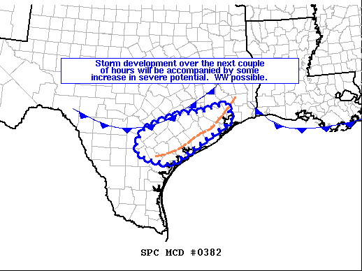
Areas affected...portions of the Texas Coastal Plain
Concerning...Severe potential...Watch possible
Valid 141743Z - 141945Z
Probability of Watch Issuance...40 percent
SUMMARY...Storm development over the next couple of hours will be
accompanied by some increase in risk for large hail and locally
strong/damaging wind gusts through this afternoon. A WW may be
required.
DISCUSSION...Latest surface analysis shows a cold front across
western portions of the Texas Coastal Plain/eastern fringes of the
Hill Country, and then westward into the Edwards Plateau.
Meanwhile, a sea-breeze boundary has pushed into coastal counties,
with high theta-e marine air along and east of this boundary.
Though capping (near 700 mb) remains established across the area,
continued heating/mixing of the boundary layer will weaken the cap
locally -- particularly near the aforementioned surface boundaries
where ascent is locally maximized. With steep lapse rates overlying
this region above the capping layer, the destabilizing environment
-- represented by mixed-layer CAPE values now in excess of 2500 J/kg
across the region per RUC-based objective analyses -- combined with
the weakening cap will support local/robust updraft development.
While deep-layer shear is not excessive, partially owing to modest
low-level flow, ample (around 30 kt) mid-level west-southwesterlies
are contributing to shear sufficient for multicell organization, and
even some mid-level updraft rotation. As such, potential for hail
and/or locally strong outflow winds will be possible with a few of
the strongest storms. We will continue to monitor development, for
signs that convective development/coverage may warrant WW issuance.
..Goss/Thompson.. 04/14/2021
...Please see www.spc.noaa.gov for graphic product...
ATTN...WFO...HGX...CRP...EWX...
LAT...LON 29279811 29559761 29829683 29909598 30189492 29659475
28749616 28169709 28299783 28449828 28839839 29279811
|
|
Top/All Mesoscale Discussions/Forecast Products/Home
|
|


 @NWSSPC