|
| Mesoscale Discussion 421 |
|
< Previous MD Next MD >
|

|
   Mesoscale Discussion 0421
   NWS Storm Prediction Center Norman OK
   0910 AM CDT Sat Apr 24 2021

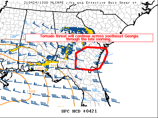
   Areas affected...southeast Georgia and far southern South Carolina

   Concerning...Severe potential...Watch likely

   Valid 241410Z - 241545Z

   Probability of Watch Issuance...80 percent

   SUMMARY...Well established squall line with embedded areas of
   rotation persists this morning across southern Georgia and northern
   Florida. A new watch will likely be needed downstream of Tornado
   Watch #106.

   DISCUSSION...A well established quasi-linear convective system, with
   embedded meso-vortices, continues moving east across southern
   Georgia this morning. The airmass feeding these storms is best
   characterized by mixed-layer CAPE on the order of 500 J/kg and
   deep-layer shear around 70 knots. This is sufficient to maintain
   QLCS organization for the next few hours as storms continue across
   Tornado Watch #106. The forward speed of this complex will result in
   thunderstorms exiting existing watches later this morning. The
   airmass downstream of ongoing watches is drier than farther west as
   low-level trajectories have slowed the return of better/richer
   moisture. A consequence of this is that thunderstorms will quickly
   outpace the return of the stronger instability. Despite this weaker
   instability, the well established nature of the thunderstorm complex
   combined with the strong deep-layer shear should compensate somewhat
   for the lack of better instability and a severe threat should
   persist across southeast Georgia through the morning hours.

   A new watch will likely be issued soon for portions of southeast
   Georgia and far southern South Carolina.

   ..Marsh/Hart.. 04/24/2021

   ...Please see www.spc.noaa.gov for graphic product...

   ATTN...WFO...CHS...JAX...FFC...TAE...

   LAT...LON   31868333 32308240 32258127 32208067 31858054 31168090
               30708127 30578192 30638266 30708334 31868333
|
|
Top/All Mesoscale Discussions/Forecast Products/Home
|
|


