|
| Mesoscale Discussion 455 |
|
< Previous MD Next MD >
|
|
Mesoscale Discussion 0455
NWS Storm Prediction Center Norman OK
0340 PM CDT Wed Apr 28 2021
Areas affected...Portions of central TX
Concerning...Tornado Watch 119...
Valid 282040Z - 282215Z
The severe weather threat for Tornado Watch 119 continues.
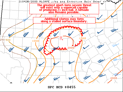
SUMMARY...The greatest short-term severe threat will exist with a
supercell capable of producing 2+ inch hail. A tornado also remains
possible. Additional storms may form along a stalled surface
boundary.
DISCUSSION...A severe supercell moving from Runnels/Taylor counties
into Callahan/Coleman counties in central TX will continue to pose a
threat for large to very large (2+ inch) hail in the short term.
Surface observations to the south/southeast of this ongoing storm
indicate surface temperatures have warmed into the mid to upper 80s,
while dewpoints remain in the mid to upper 60s. Accordingly,
instability is maximized near this supercell per latest mesoanalysis
estimates, with MLCAPE around 2000 J/kg. Low-level flow appears
fairly week based on recent VWPs from KDYX, but it does strengthen
some with eastward extent into central TX. A tornado remains
possible in the short term with any supercell that can remain
sustained, but large hail will likely remain the primary severe risk
for the next hour or two. Additional storms may form along a stalled
outflow boundary that is draped across this region, particularly
where this boundary intersects a surface dryline near San Angelo TX.
Any additional convection that develops will likely become severe
quickly and pose at a very large hail threat.
..Gleason.. 04/28/2021
...Please see www.spc.noaa.gov for graphic product...
ATTN...WFO...FWD...SJT...
LAT...LON 31619919 31619992 31340026 31330047 31560046 32280018
32549965 32639925 32519846 32239838 31839855 31619919
|
|
Top/All Mesoscale Discussions/Forecast Products/Home
|
|


 @NWSSPC