|
| Mesoscale Discussion 472 |
|
< Previous MD Next MD >
|
|
Mesoscale Discussion 0472
NWS Storm Prediction Center Norman OK
0147 PM CDT Sun May 02 2021
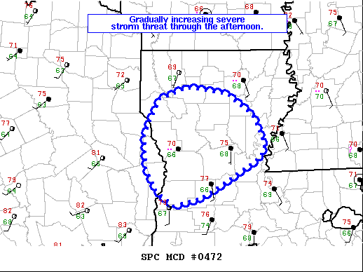
Areas affected...Central Louisiana and far east Texas
Concerning...Severe potential...Watch unlikely
Valid 021847Z - 022015Z
Probability of Watch Issuance...20 percent
SUMMARY...A gradual increase in storm intensity is expected through
the afternoon. Isolated large hail and damaging wind gusts along
with a tornado or two will be the primary threats.
DISCUSSION...An area of showers has shown gradually cooling cloud
tops over the past hour. The environment is currently not overly
favorable for severe weather with MLCAPE around 500 to 1000 J/kg and
a mostly unidirectional wind profile. However, additional heating
and low-level moisture advection is expected to yield greater
instability by later this afternoon in the 1000-1500 J/kg range.
This may be sufficient for a few stronger updrafts and supercell
structures given 35 to 40 knots of effective shear. Weak rotation in
most of the ongoing showers further supports the potential for
supercell structures, at least initially. Veered low-level flow
should limit the overall tornado threat, but moderate speed shear
(0-1 km shear around 25 kts per KPOE VWP) and more backed low-level
flow across northeast Louisiana may support a tornado or two by
later this afternoon/evening.
A watch is possible, but the limited area and duration of the threat
may preclude the need for a watch.
..Bentley/Dial.. 05/02/2021
...Please see www.spc.noaa.gov for graphic product...
ATTN...WFO...JAN...LCH...SHV...
LAT...LON 32209366 32399313 32289234 31929187 31459165 31269173
30989219 30599286 30479339 30689369 31089390 31649394
32209366
|
|
Top/All Mesoscale Discussions/Forecast Products/Home
|
|


 @NWSSPC