|
| Mesoscale Discussion 480 |
|
< Previous MD Next MD >
|
|
Mesoscale Discussion 0480
NWS Storm Prediction Center Norman OK
0651 PM CDT Sun May 02 2021
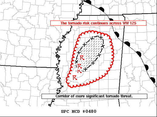
Areas affected...Central Mississippi
Concerning...Tornado Watch 125...
Valid 022351Z - 030045Z
The severe weather threat for Tornado Watch 125 continues.
SUMMARY...Supercells with a history of tornadoes will likely persist
through early evening where a corridor of greater tornado risk
appears likely this evening.
DISCUSSION...Several small supercells along and west of I-55 have
produced confirmed tornadoes over the last 90 minutes. KDGX analysis
shows several low-level mesocyclones with VROTs of 40-50 kts and a
considerable TDS near Yazoo City, MS. SPC mesoanalysis and regional
VWPS show strong veering wind profiles with 200-300 m2/s2 ESRH ahead
of the ongoing storms to near the warm front across north-central
Mississippi. A corridor of greater tornado potential is likely
evolving. The potential exists for several additional tornadoes,
(possibly significant) to develop and track northeastward to the
warm front over the next 1 to 3 hours.
..Lyons.. 05/02/2021
...Please see www.spc.noaa.gov for graphic product...
ATTN...WFO...MEG...JAN...
LAT...LON 32909053 33579039 34239013 34388969 34298927 34198886
33558871 33178875 32808902 32658931 32468980 32419002
32349060 32569071 32909053
|
|
Top/All Mesoscale Discussions/Forecast Products/Home
|
|


 @NWSSPC