|
| Mesoscale Discussion 501 |
|
< Previous MD Next MD >
|
|
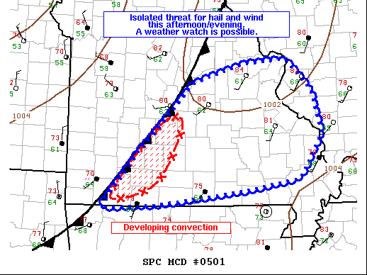
   Mesoscale Discussion 0501
   NWS Storm Prediction Center Norman OK
   0451 PM CDT Mon May 03 2021

   Areas affected...portions of southern Missouri and far southwestern
   Illinois

   Concerning...Severe potential...Watch possible

   Valid 032151Z - 032315Z

   Probability of Watch Issuance...40 percent

   SUMMARY...An isolated threat for damaging winds and hail is possible
   with developing thunderstorms near Springfield, MO. A watch is
   possible but high uncertainty remains.

   DISCUSSION...Afternoon water vapor imagery showed a small shortwave
   trough/ MCV moving across a stalled cold front along the Mississippi
   River Valley into the Midwest. Heating along the front has eroded
   the majority of MLCINH across southwestern Missouri. SPC
   mesoanalysis indicates surface dewpoints in the low to middle 60s F
   and lapse mid-level lapse rates near 8 C/km are supporting 1500-2500
   J/kg of MLCAPE. Flow aloft is not overly strong, but mid-level flow
   around 30 kts maybe be sufficient to support marginal supercells.
   Latest WOFS guidance indicates a moderate probability (50-70%) that
   the ongoing storms along the I-44 corridor will reach severe
   criteria over the next couple of hours. With veered low-level winds
   decreasing effective hodograph size, the primary severe threats will
   be large hail and damaging wind gusts.

   Considerable uncertainty remains on the coverage, longevity, and
   severity of storms as they translate northeastward over the next
   couple of hours. The favorable thermodynamics and marginal shear
   parameter space suggest some severe threat may materialize.
   Conditions will be monitored for a possible severe thunderstorm
   watch.

   ..Lyons/Thompson.. 05/03/2021

   ...Please see www.spc.noaa.gov for graphic product...

   ATTN...WFO...PAH...LSX...SGF...TSA...

   LAT...LON   36719371 37379316 37889265 38459207 38759107 38839019
               38348969 37638949 36928994 36759100 36539278 36469392
               36719371
|
|
Top/All Mesoscale Discussions/Forecast Products/Home
|
|


 @NWSSPC