|
| Mesoscale Discussion 560 |
|
< Previous MD Next MD >
|
|
Mesoscale Discussion 0560
NWS Storm Prediction Center Norman OK
0324 PM CDT Sat May 08 2021
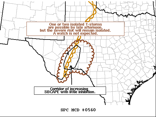
Areas affected...The Big Bend region of southern Texas
Concerning...Severe potential...Watch unlikely
Valid 082024Z - 082130Z
Probability of Watch Issuance...20 percent
SUMMARY...One or two thunderstorms may develop by late afternoon
across southern Texas. However, the severe threat is expected to
remain isolated, and a watch is not expected.
DISCUSSION...Recent GOES imagery shows a growing field of agitated
cumulus in the Fort Stockton, TX area along a semi-diffuse dryline.
This region is on the periphery of richer boundary-layer moisture
with dewpoints only reaching the low 50s on the moist side of the
confluence axis. However, RAP mesoanalysis and forecast soundings
suggest a narrow corridor may exist where sufficient moisture and
boundary-layer heating (surface temperatures in the low 90s are
noted in the region) will support 500-1000 J/kg SBCAPE with minimal
inhibition. Recent HRRR guidance suggests a storm or two may develop
in this corridor and/or within the higher terrain of northern Mexico
by late afternoon. Given 30-40 knots of effective bulk shear, storm
organization is likely and may support an isolated hail/wind threat.
Any storm that can initiate will encounter a higher MUCIN
environment as it moves eastward into south-central TX. This casts
some uncertainty into the duration of any robust convection. Given
the isolated, and possibly short duration, nature of this threat, a
watch is not expected.
..Moore/Thompson.. 05/08/2021
...Please see www.spc.noaa.gov for graphic product...
ATTN...WFO...EWX...SJT...MAF...
LAT...LON 28960345 29810335 30800302 31360253 31910198 31920125
31530059 30780046 29770100 29370116 29580149 29670181
29700218 29550255 29240272 29050286 28830301 28850327
28960345
|
|
Top/All Mesoscale Discussions/Forecast Products/Home
|
|


 @NWSSPC