|
| Mesoscale Discussion 591 |
|
< Previous MD Next MD >
|
|
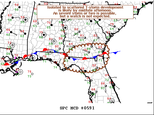
   Mesoscale Discussion 0591
   NWS Storm Prediction Center Norman OK
   1212 PM CDT Tue May 11 2021

   Areas affected...North Florida and south-central Georgia

   Concerning...Severe potential...Watch unlikely

   Valid 111712Z - 111915Z

   Probability of Watch Issuance...5 percent

   SUMMARY...Isolated to scattered thunderstorms are expected to
   develop by the mid to late afternoon hours. One or two severe storms
   are possible, but the threat will likely remain too limited to
   warrant a watch issuance.

   DISCUSSION...Regional radar trends over the past hour have shown
   scattered convective showers developing over northern FL and
   southern GA in the vicinity of a diffuse confluence axis. GOES IR
   imagery shows fairly warm cloud tops, indicating that deeper
   convection has not yet been achieved. However, surface temperatures
   are warming into the low 80s and will likely reach surface-based
   parcel convective temperatures by mid afternoon as warming continues
   into the mid/upper 80s. Modified morning soundings from north FL
   suggest MLCAPE is increasing upwards of 500 J/kg, and recent RAP
   analyses show a similar trend that will likely continue through the
   remainder of the day. Lift within the weak confluence axis may allow
   for isolated to scattered thunderstorms by mid to late afternoon.
   While this region is on the periphery of stronger upper-level flow
   to the north, 30-40 knots of effective bulk shear should support
   some storm organization and the potential for an isolated wind/hail
   threat. Mean deep-layer flow along the confluence axis will likely
   favor clusters of storms that may favor a wind threat over severe
   hail, but the overall threat is expected to be fairly isolated and a
   watch is not expected.

   ..Moore/Thompson.. 05/11/2021

   ...Please see www.spc.noaa.gov for graphic product...

   ATTN...WFO...CHS...JAX...TAE...

   LAT...LON   31068455 31458395 31588310 31648240 31638146 31418104
               30628110 29998136 29598245 29598351 29758442 29948492
               30518491 31068455
|
|
Top/All Mesoscale Discussions/Forecast Products/Home
|
|


 @NWSSPC