|
| Mesoscale Discussion 620 |
|
< Previous MD Next MD >
|
|
Mesoscale Discussion 0620
NWS Storm Prediction Center Norman OK
0225 PM CDT Sat May 15 2021
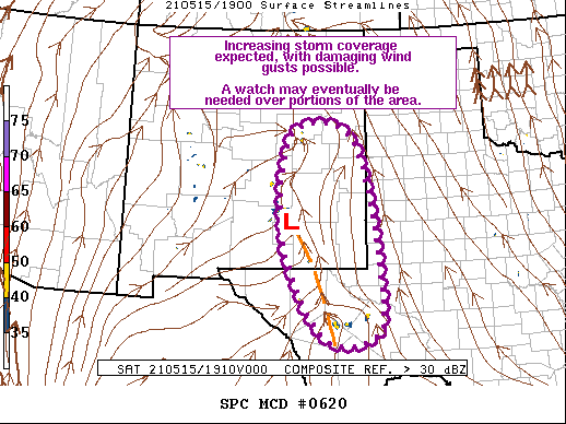
Areas affected...East-Central/Southeast NM...TX Trans Pecos
Concerning...Severe potential...Watch possible
Valid 151925Z - 152200Z
Probability of Watch Issuance...60 percent
SUMMARY...Thunderstorm coverage is expected to increase over the
next few hours, with some strong to severe storms probable. Primary
severe threat will be strong damaging wind gusts, although a few
instances of hail are also possible. General convective trends will
be monitored closely for possible watch issuance.
DISCUSSION...Visible satellite imagery shows increasing (both
spatially and in depth) cumulus field across much of the southern
High Plains. Deepest cumulus as well as highest number of lightning
strikes have occurred from roughly TCC (in east-central NM)
southward to west of FST (in the TX Trans Pecos). Surface
observations within this corridor reveal temperatures in the mid to
upper 80s and dewpoints in the low 50s. Mesoanalysis is estimating
little to no convective inhibition remains. Given the airmass
destabilization, persistent convergence along the lee trough coupled
with orographic effects and increasing large-scale forcing for
ascent, attendant to an approaching shortwave trough, will likely
result in additional storm development throughout the afternoon.
Deep boundary-layer mixing is ongoing and any storms that do develop
will move into an environment very conducive for damaging wind
gusts. Some hail is also possible, but modest deep-layer vertical
shear and marginal buoyancy should restrain the overall hail
potential. Given the likelihood for strong storm outflow, individual
storm persistence will likely be limited but additional development
along storm outflow appears probable.
..Mosier/Guyer.. 05/15/2021
...Please see www.spc.noaa.gov for graphic product...
ATTN...WFO...LUB...MAF...ABQ...EPZ...
LAT...LON 33530516 34900475 34570332 31340271 30540304 30590410
31970492 33530516
|
|
Top/All Mesoscale Discussions/Forecast Products/Home
|
|


 @NWSSPC