|
| Mesoscale Discussion 625 |
|
< Previous MD Next MD >
|
|
Mesoscale Discussion 0625
NWS Storm Prediction Center Norman OK
0617 PM CDT Sat May 15 2021
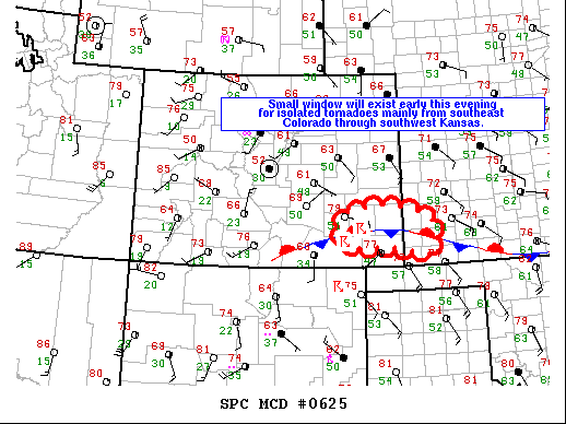
Areas affected...southeast Colorado through southwest Kansas
Concerning...Tornado Watch 175...
Valid 152317Z - 160015Z
The severe weather threat for Tornado Watch 175 continues.
SUMMARY...A relatively small window will exist through mid evening
for brief isolated tornadoes from a portion of southeast Colorado
through southwest Kansas.
DISCUSSION...Early this evening a stationary boundary extends
through southwest Kansas into southeast Colorado. Dewpoints are
generally in the upper 50s to around 60 F in vicinity of this
boundary contributing to somewhat lower LCLs and up to 2000 J/kg
MLCAPE. Storms will continue spreading eastward off the higher
terrain, and other storms may initiate on the boundary. Effective
bulk shear around 35 kt will promote both multicell and marginal
supercell structures, and some increase in 0-2 km hodograph size
will occur as the low-level jet strengthens this evening. The
primary threat for a few brief tornadoes is expected to occur as
storms develop along or move east and interact with the boundary
where low-level vorticity will be maximized.
..Dial.. 05/15/2021
...Please see www.spc.noaa.gov for graphic product...
ATTN...WFO...DDC...PUB...
LAT...LON 37240133 37400237 37420350 38040358 38260247 37920123
37240133
|
|
Top/All Mesoscale Discussions/Forecast Products/Home
|
|


 @NWSSPC