|
| Mesoscale Discussion 628 |
|
< Previous MD Next MD >
|
|
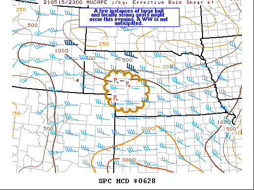
   Mesoscale Discussion 0628
   NWS Storm Prediction Center Norman OK
   0712 PM CDT Sat May 15 2021

   Areas affected...southwest Nebraska

   Concerning...Severe potential...Watch unlikely

   Valid 160012Z - 160115Z

   Probability of Watch Issuance...20 percent

   SUMMARY...Thunderstorms developing over southwest Nebraska this
   evening might become capable of producing isolated large hail and
   locally strong wind gusts. Overall threat will probably not warrant
   a WW, but trends will continue to be monitored.

   DISCUSSION...Storms are currently developing across southwest NE
   within a weak warm advection regime, and additional storms are
   expected this evening as the southerly low-level jet strengthens.
   Widespread clouds have limited surface heating resulting in modest
   MLCAPE (500-1000 J/kg). However, vertical wind profiles with up to
   40 kt effective bulk shear (as sampled by the 00Z North Platte RAOB)
   will be sufficient for a few rotating updrafts which along with
   7-7.5 C/km mid-level lapse rates will support the potential for a
   few instances of large hail. Activity might eventually evolve into a
   small MCS before weakening later this evening.

   ..Dial/Grams.. 05/16/2021

   ...Please see www.spc.noaa.gov for graphic product...

   ATTN...WFO...LBF...BOU...

   LAT...LON   40490208 41430251 41940230 41800109 41370020 40450063
               40490208
|
|
Top/All Mesoscale Discussions/Forecast Products/Home
|
|


 @NWSSPC