|
| Mesoscale Discussion 754 |
|
< Previous MD Next MD >
|
|
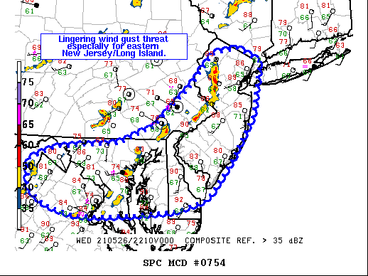
   Mesoscale Discussion 0754
   NWS Storm Prediction Center Norman OK
   0534 PM CDT Wed May 26 2021

   Areas affected...Portions of Mid-Atlantic

   Concerning...Severe Thunderstorm Watch 205...206...

   Valid 262234Z - 270030Z

   The severe weather threat for Severe Thunderstorm Watch 205, 206
   continues.

   SUMMARY...Damaging wind gusts remain a concern with convection
   nearing the Atlantic Coast. A few isolated storms near the Blue
   Ridge and along the cold front may pose a low-end threat for strong
   winds.

   DISCUSSION...The most intense and organized convection near the
   Atlantic Coast will impact portions or northern and central New
   Jersey into western Long Island. Surface observations show much
   cooler air in central and eastern Long Island. Parts of this
   convective line will likely move offshore within the next hour. With
   a narrow corridor of temperatures into the mid/upper 80s F, damaging
   gusts will be possible in the short term. In Maryland and northern
   Virginia, convection has been more of a broken line. A similar
   hot/unstable airmass is ahead of a cluster now approaching the
   Delmarva. Damaging gusts will be possible here for the next 1-1.5
   hours. A small cluster has recently developed along the Blue Ridge
   and is moving east. This may pose a threat for damaging gusts as
   well, but stable air awaits this activity in the wake of early
   convection and continued loss of boundary-layer heating. This threat
   will be likely short-lived.

   Farther north and west along the synoptic cold front, lingering
   convection may persist this evening. With the boundary layer
   stabilizing, isolated strong gusts would be the main threat before
   this activity diminishes.

   ..Wendt.. 05/26/2021

   ...Please see www.spc.noaa.gov for graphic product...

   ATTN...WFO...OKX...PHI...AKQ...CTP...LWX...

   LAT...LON   39357857 39547805 39637674 39877618 39897605 40607522
               41087479 41177428 40947381 40097397 39357445 38777493
               38587553 38517645 38497705 38487761 38637821 38907860
               39357857
|
|
Top/All Mesoscale Discussions/Forecast Products/Home
|
|


 @NWSSPC